Maps of Königs Wusterhausen

Maps of Königs Wusterhausen

$title$

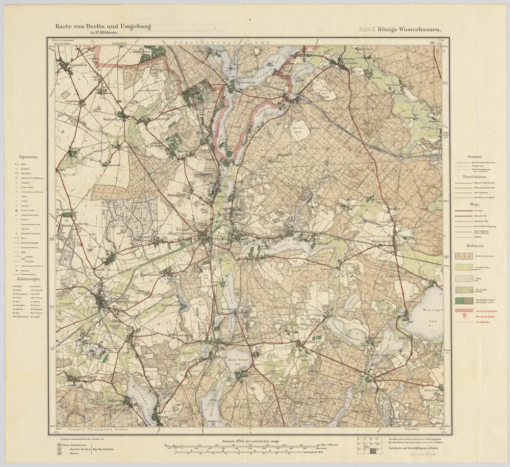
Blatt XI Königs-Wusterhausen, uit: Karte von Berlin und Umgebung in 12 Blättern

1 : 50000 Annotatie: Toelichtingen opgeborgen bij kaart; Annotatie geografische gegevens: Met schaalstokken: Meter, Schritt, geographische Meile Paul Schneider Berlin : Reichsamt für Landesaufnahme
$title$

Meßtischblatt 3748 : Friedersdorf, 1941

1 : 250000 Friedersdorf. - Aufn. 1901, hrsg. 1903, bericht. 1920, letzte Nachtr. 1940. - 1:25000. - [Berlin]: Reichsamt für Landesaufnahme, 1941. - 1 Kt.
$title$

Meßtischblatt 2045 : Friedersdorf, 1920

1 : 250000 Friedersdorf. - Aufn. 1901, bericht. 1920. - 1:25000. - [Berlin]: Preuß. Landesaufnahme, 1920. - 1 Kt.
$title$

Meßtischblatt 2045 : Friedersdorf, 1906

1 : 250000 Friedersdorf. - Aufn. 1901, hrsg. 1903, gedr. [19]06. - 1:25000. - [Berlin]: Reichsamt für Landesaufnahme, 1906. - 1 Kt.
$title$

Meßtischblatt 3747 : Mittenwalde, 1941

1 : 250000 Mittenwalde. - Hrsg. 1903, bericht. 1933, letzte Nachtr. 1940, Ausg. 1941. - 1:25000. - [Berlin]: Reichsamt für Landesaufnahme, 1941. - 1 Kt.
$title$

Meßtischblatt 2044 : Mittenwalde, 1925

1 : 250000 Mittenwalde. - Aufn. 1901, bericht. 1920, gedr. [19]25. - 1:25000. - [Berlin]: Preuß. Landesaufnahme, 1925. - 1 Kt.
$title$

Meßtischblatt 3747 : Mittenwalde, 1898

1 : 250000 Mittenwalde. - 1:25000. - [Berlin]: Reichsamt für Landesaufnahme, 1898. - 1 Kt.
$title$

Meßtischblatt 1977 : Königs- Wusterhausen, 1930

1 : 250000 Königs- Wusterhausen. - Hrsg. 1903, bericht. 1919, einz. Nachtr. 1930. - 1:25000. - [Berlin]: Reichsamt für Landesaufnahme, 1930. - 1 Kt.
$title$

Meßtischblatt 1977 : Königs- Wusterhausen, 1912

1 : 250000 Königs- Wusterhausen. - Aufn. 1901, hrsg. 1903, einz. Nachtr. 1912. - 1:25000. - [Berlin]: Königl. Preuss. Landesaufnahme, 1912. - 1 Kt.
$title$

Meßtischblatt 3648 : Wernsdorf, 1942

1 : 250000 Wernsdorf. - Aufn. 1901, hrsg. 1903, bericht. 1920, letzte Nachtr. 1940, Ausg. 1942. - 1:25000. - [Berlin]: Preußische Landesaufnahme, Hauptvermessungsabt. IV, 1942. - 1 Kt.
$title$

Meßtischblatt 3648 : Wernsdorf, 1937

1 : 250000 Wernsdorf. - Hrsg. 1903, bericht. 1920, einz. Nachtr. 1936/37. - 1:25000. - [Berlin]: Reichsamt für Landesaufnahme, 1937. - 1 Kt.
$title$

Meßtischblatt 1978 : Wernsdorf, 1936

1 : 250000 Wernsdorf. - Hrsg. 1903, bericht. 1920, einz. Nachtr. 1936. - 1:25000. - [Berlin]: Reichsamt für Landesaufnahme, 1936. - 1 Kt.
$title$

Meßtischblatt 1978 : Wernsdorf, 112

1 : 250000 Wernsdorf. - Aufn. 1901, hrsg. 1903, N. 12. - 1:25000. - [Berlin]: Königl. Preuss. Landesaufnahme, 1912. - 1 Kt.
$title$

294. Copenick.

1 : 100000 Reichsamt fur Landesaufnahme
$title$

Composite: 294. Copenick.

1 : 100000 Reichsamt fur Landesaufnahme
$title$

90. Berlin (Süd), uit: Topographische Uebersichtskarte des Deutschen Reiches / herausgegeben v. d. Kartogr. Abt. d. Königl. Preuß. Landesaufnahme

1 : 200000 titelvariant: Topogr. Übersichtskarte des Deutschen Reiches; Annotatie: Titel boven bladen ook: Topogr. Übersichtskarte des Deutschen Reiches; Annotatie geografische gegevens: Op elk blad twee maatstokken: 10 Kilometer = 5,5 cm; 1 geogr. Meile = 3,6 cm; Legenda onder op elk blad Königlich Preußische Landesaufnahme. Kartographische Abtheilung [S.l : Königlich Preußische Landesaufnahme, Kartographische Abtheilung]
$title$

Geologische Übersichtskarte der Umgegend von Berlin

1 : 100000 Berendt, G. ; Laufer, E. Lithogr. Institut
$title$

$title$

Topographische Carte : Hundert Quadrat-Meilen um Berlin

1 : 184000
$title$

Accurate Geographische Delineation Derer Zum Fürstenthum Querfurth gehörigen zwey Aemmter Dahme und Jüterbog

1 : 120000 Mollova mapová sbírka Schenk, Pieter Schenk, Peter II
$title$

Praefecturae Principatus Querfurtensis Dahmiana Et Iüterboccensis

1 : 120000 Mollova mapová sbírka Lotter, Tobias Conrad Seutter, Matthäus
$title$

Der Teltowische Creis

1 : 300000 Oesfeld, Karl Ludwig von Jättnig, Karl
$title$

Praefecturae principatus querfurtensis Dahmiana et Iüterboccensis cum vicinia oppidis, vicis, pagis accurate distincta

1 : 130000 Braniborsko (Německo) Seutter, Matthäus Lotter, Tobias Conrad M. Seutter
$title$

Carte Geographique, ou on fait voir le Dvche de Saxonie nome. le Cercle Electorale :

1 : 110000 Mollova mapová sbírka Homann, Johann Baptist Homann, Johann Baptista - dědici
$title$

Taschenplan von Berlin

$title$

86. Berlin, Districts of Leipzig, Dresden, Karl-Marx-Stadt. The World Atlas.

1 : 1250000 USSR (Union of Soviet Socialist Republics).
$title$

Composite: 318. Zossen.

1 : 100000 Reichsamt fur Landesaufnahme
$title$

318. Zossen.

1 : 100000 Reichsamt fur Landesaufnahme
$title$

Berlin unter alliierter Verwaltung 1.9.1945

Berlin Kunz, Andreas ; Moeschl, Joachim Robert
$title$

Marchionatus Lusatiae inferioris Bohemiae olim regno jam elect. Saxoniae subject in circulos, dynastias et praefect. accuratissime distinctus

1 : 180000 Horní Lužice (Německo) Seutter, Matthäus Lotter, Tobias Conrad sumtibus Matth. Seutteri
© MapTiler © OpenStreetMap contributors
How does it work?
These instructions will show you how to find historical maps online.
Getting started
Type the place name in the search box to find the exact location. You can further adjust the search by zooming in and out.
Zoom
Zoom in and out with the buttons or use your mouse or touchpad natively.
Exact Area tool
Click here and draw a rectangle over the map to precisely define the search area.
Set filters
Narrow your search with advanced settings, such as Years (from/to), Fulltext, Publisher, etc.
Results
See the results of your search on the right side. You can scroll down to find more maps of this location.
?

Download OldMapsOnline Mobile