Maps of Schwyz
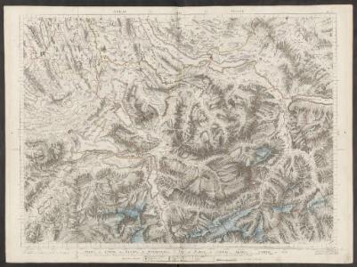
Partie du canton de Lucerne, d'Unterwalden, d'Uri et Zurich, le canton Glarus, Schweiz et Zug
1 : 108000 Weiss, Johann Heinrich ; Eichler, Matthias-Gottfried ; Meyer, Johann Rudolf J. R. Meyer
Atlas Suisse
1 : 120000 16 Karten levé et dessiné par J.H. Weiss [et Joachim Eugen Müller] aux frais de J.R. Meyer à Aarau dans les années 1786 à 1802 ; gravée [sic] par [Christophe] Guérin, [Matthias Gottfried] Eichler et [Johann Jakob] Scheurmann [Johann Rudolf Meyer], Aarau
Karte der Kantone Schwyz und Zug
1 : 250000 1 Karte J. Wurster u. Comp., Winterthur
<<Die>> Cantone Schweiz und Zug
1 : 180000 1 Karte gest. v. J. Scheurman [Orell Füssli & Comp.], [Zürich]
Partie du canton de Lucerne, d'Unterwalden, d'Uri et Zurich, le canton Glarus Schweiz et Zug
1 : 122000 Curych (Švýcarsko : kanton) Weiss, J. H. Eichler, M. G.
<<Die>> Cantone Schwyz und Zug
1 : 180000 1 Karte gest. von J. Scheurman Orell Füssli & Cp., Zürich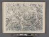
Partie du Canton de Lucerne d'Unterwalden d'Uri et Zurich le Canton Glarus Schweiz et Zug.
From Atlas Suisse. Levé et dessiné par J. H. Weiss aux fraix de J. R. Meyer á Aarau dans les années 1786 á 1802. Gravée par Guerin, Eichler, et Scheurmann.
Karte der centralen Schweiz
1 : 200000 1 Karte von R. Leuzinger ; Schrift gestochen von P. Steiner bei Heinrich Fuessli u. Comp., Zürich
Karte der Kantone Schwyz und Zug
1 : 250000 1 Karte J. Wurster u. Comp., Winterthur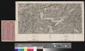
Panorama des Vierwaldstättersee's & seiner Umgebungen
1 : 135000 1 Vogelschaukarte [nach Friedrich Wilhelm Delkeskamp] Ruff u. Hofer, Zürich
Tugeni in Helvetiis
1 : 250000 Mollova mapová sbírka Sanson, Nicolas Liébaux, Jean-Baptiste Mariette, Pierre
Kantone Zürich, Schwyz, Glarus und St. Gallen: Einzugsgebiet Linth-Limmat, Abwasserkataster: Belastung durch Abwasserstoffe; Übersichtsplan (Nr. II)
1 : 100000 Mit Angabe der Kantons- und Gemeindegrenzen, der Gewässer und Eisenbahnlinien, der bestehenden und projektierten Anlagen, der massgebenden Einwohnerzahl (häuslicher und industrieller Anteil) pro Gemeinde sowie der Gemeinden ohne Katasterblatt. Zeichnung: Ingenieurbüro H. Eichenberger, in Zürich. Herausgeber: Linth-Limmatverband
Kantone Zürich, Schwyz, Glarus und St. Gallen: Einzugsgebiet Linth-Limmat, Abwasserkataster: Einzugsgebiet; Übersichtsplan (Nr. I)
1 : 100000 Mit Angabe der Kantons- und Gemeindegrenzen, der Gewässer und Eisenbahnlinien, der Kanalisation, des durch generelle Kanalisationsprojekte festgelegten Einzugsgebiets, der bestehenden und projektierten Anlagen sowie der Gemeinden ohne Katasterblatt. Zeichnung: Ingenieurbüro H. Eichenberger, in Zürich. Herausgeber: Linth-Limmatverband
<<Die>> Cantone Schwyz und Zug
1 : 180000 1 Karte gest. von J. Scheurmann Orell, Füssli & Cp., Zürich
<<Die>> Cantone Schwyz und Zug
1 : 180000 1 Karte gest. von J. Scheurmann Orell Füssli & Cp., Zürich
Atlas der Schweiz
1 : 450000 1 Atlas (18 Bl.) gez. u. gest. v. J. Scheurmann Orell Fussli, Zurich
Relief pittoresque du sol classique de la Suisse
1 Vogelschaukarte auf 9 Bl. dessiné d'après nature et gravé à l'eau forte par Frédéric Guillaume Delkeskamp ; terminé à l'aqua tinta par François Hegi et J.J. Sperli à Zuric = [Malerisches Relief des klassischen Bodens der Schweiz] / [Nach der Natur gezeichnet und radirt von Friedrich Wilhelm Delkeskamp ; in Aqua tinta vollendet von Franz Hegi und J.J. Sperli in Zürich] [Friedrich Wilhelm Delkeskamp], [Frankfurt a/M.]
Karte der centralen Schweiz
1 : 200000 Leuzinger, Rudolf ; Steiner, P. bei Heinrich Fuessli u. Comp.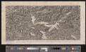
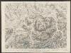
[Malerisches Relief der Schweizer- und angränzenden Alpen]
1 : 135000 11 Vogelschaukarten Nach der Natur aufgenommen und gezeichnet von F.W. Delkeskamp ; gestochen v. Knopfmacher u. J.Ph. Dauch [Friedrich Wilhelm Delkeskamp], [Frankfurt am Main]
Atlas de la Suisse
1 : 450000 1 Atlas (19 Bl.) dessiné par MM. H. Keller, Scheurmann, Pfyffer d'Altishofen, Osterwald, etc. ; gravé par M. Scheurmann Orell Füssli & Co., Zürich
Karte der Schweiz
1 : 200000 Abgebildet sind die Kantone Aargau, Zürich, Thurgau, St. Gallen, Glarus, Graubünden, Uri, Unterwalden, Luzern und Solothurn. Entwurf und Bearbeitung: Woerl Lithografie: Herder, B.
Zurich
1 : 200000 Herder, Bartholomew
<<Die>> Cantone Schwyz und Zug
1 : 180000 1 Karte gest. von J. Scheurmann Orell Füssli & Cp., Zürich
Atlas novus Reipublicae Helveticae
1 Atlas ([40] Bl., 97 S.) bey Orell, Gessner und Compagnie, Zürich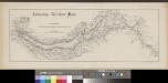
Linksufrige Zürichsee-Bahn
1 : 100000 1 Profil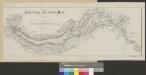
Linksufrige Zürichsee-Bahn
1 : 100000 1 Karte
<<Die>> Cantone Schwyz und Zug
1 : 180000 1 Karte gest. von J. Scheurmann Orell, Füssli & Cp., Zürich
<<Die>> Cantone Schwyz und Zug
1 : 180000 1 Karte gest. von J. Scheurmann Orell, Füssli & Cp., Zürich
Übersichtskarte der Zürichsee-Gotthardbahn
1 : 100000 1 Karte [Verlag nicht ermittelbar], [Erscheinungsort nicht ermittelbar]