Maps of Haut-Rhin

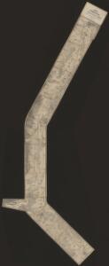
Carte du chemin de fer de Strasbourg à Bâle
1 : 80000 Lithographie de Ve Levrault
Carte du chemin de fer de Strasbourg à Bâle
1 : 80000 Lithographie de Ve Levrault
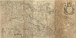
Alsatia Landgraviatus, cum Svntgoia et Brisgoia
1 : 250000 Mollova mapová sbírka Mercator, Gerhard Blaeu, Joan I.
Alsatia superior cu[m] Suntgoa et Brisgoia
1 Karte : Kupferdruck ; 17 x 24 cm Mercator Cloppenburgh
Alsatia superior cu[m] Suntgoia [et] Brisgoia
1 Karte : Kupferdruck ; 34 x 46 cm Mercator s.n.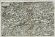
Alsatia svperior
1 Karte : Kupferdruck ; 14 x 22 cm Lambert Andreae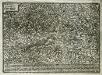
Elsatia svperior
1 Karte : Kupferdruck ; 17 x 27 cm Quad Johannes Bussemacher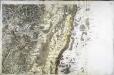
[Colmar]
1 Blatt : 60 x 91 cm s.n.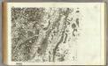
163 Colmar.
1 : 86400 Cassini family; Cassini, Cesar-Francois, 1714-1784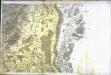
[Neuf-Brisach]
1 Blatt : 61 x 90 cm s.n.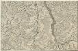
Le Cours du Rhein, depuis Spire jusqu'a Mayence
1 : 180000 Mollova mapová sbírka Fer, Nicolas de Starckman, P. Fer, Nicolas de
Le Theatre de la Guerre Sur le Haut Rhein
1 : 142000 Mollova mapová sbírka Sanson, Guillaume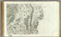
164 Neuf-Brisach.
1 : 86400 Cassini family; Cassini, Cesar-Francois, 1714-1784
Le cours du Rhin de Bâle à Hert près Philisbourg contenant l'Alsace et partie du Brisgau, 3
1 Blatt : 77 x 52 cm Le Rouge
Le cours du Rhin de Bâle à Hert près Philisbourg contenant l'Alsace et partie du Brisgau, 2
1 Blatt : 75 x 52 cm Le Rouge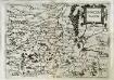
Svnggoia
1 Karte : Kupferdruck ; 15 x 20 cm Lambert Andreae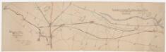
Laufen-Uhwiesen bis Ensisheim (Frankreich): Projektierte Schifffahrtsverbindung Ill-Rhein-Bodensee-Donau; Situationspläne: Fluss- und Kanalsystem zwischen Ensisheim (Frankreich) und Hüningen (Frankreich) mit projektierter Kanalanlage zwischen der Ill bei Mülhausen und dem Hüninger Zweigkanal; Situationsplan
1 : 25000 Mit Legende. Nico, Eugène

Le Flambeau de la Guerre Allumee au Rhin
Mollova mapová sbírka Delisle, Guillaume Schenk, Peter II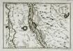
Les environs des deux Brisachs
1 Karte : Kupferdruck ; 23 x 33 cm Fer; Inselin Nicolas de Fer
Le Flambeau de la Guerre Allumee au Rhin
Mollova mapová sbírka Delisle, Guillaume Schenk, Peter II
Wandkarte von Basel und Umgebung
1 : 50000 1 Karte in 4 Teilen bearbeitet von J. Randegger Carl Detloff, Basel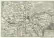
Basel u. Hunigen mitt ihren umbliegenden örthern Basle et Hunigen avec leurs environs
1 : 160000 Mollova mapová sbírka Person, Nikolaus Person, Nicolas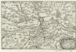
Strasburg
1 : 160000 Mollova mapová sbírka Person, Nikolaus Person, Nicolas
Le Flambeau de la Guerre Allumee au Rhin
Mollova mapová sbírka Delisle, Guillaume Schenk, Peter II
Carte Tres Particuliere Des Environs de la Ville de Strasbourg Avec toutes les subdivisions des Terres y comprises
1 : 130000 Mollova mapová sbírka Sengre, Henri Sengre, Henry
Accuratissima Territorij Argentoratensis et Annexorum Tabella In lucem edita
1 : 90000 Mollova mapová sbírka Person, Nikolaus Person, Nicolas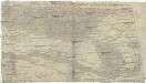
Charte über das Grosherzogthum Baaden
1 : 180000 Bádensko (Německo)