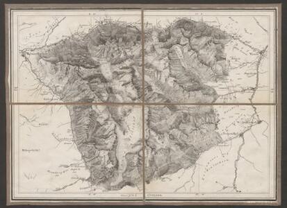
Maps of Göschenen
Excursionskarte des Alpenclub
1 : 100000 Leuzinger, Rudolf [s.n.]
Gotthardbahnstrecke Erstfeld-Castione; geologische Übersichtskarten: Blatt III: Gebiet Wassen-Andermatt
1 : 25000 Auftraggebung: Direktion der Gotthardbahn Stapff, F. M., einst Vorstand der geologisch-montanistischen Abteilung bei der Zentralbauleitung der Gotthardbahn Berliner lithogr. Institut, Berlin Druck: J. F. Starke, Berlin
Geologische Uebersichtskarte der Gotthardbahnstrecke
1 : 25000 Blatt 3 Stapff, Friedrich Moritz [s.n.]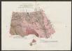
Geologische Uebersichtskarte der Gotthardbahnstrecke
1 : 25000 Blatt 4 Stapff, Friedrich Moritz [s.n.]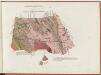
Gotthardbahnstrecke Erstfeld-Castione; geologische Übersichtskarten: Blatt IV: Gebiet Hospental
1 : 25000 Auftraggebung: Direktion der Gotthardbahn Stapff, F. M., einst Vorstand der geologisch-montanistischen Abteilung bei der Zentralbauleitung der Gotthardbahn Berliner lithogr. Institut, Berlin Druck: J. F. Starke, Berlin
[Gotthardbahnlinie]
1 : 5000 3 Karten von F. Becker ; photolithographisch reduziert auf den Massstab 1:5 000 von Brunner & Hauser Brunner & Hauser, Zürich
Transitus per summas Gotthardi Alpes
1 Vogelschaukarte J.M.F. [i.e. Johann Melchior Füssli] f. [Verlag nicht ermittelbar], [Erscheinungsort nicht ermittelbar]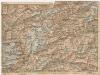
[Andermatt und Umgebung]
1 : 250000 Alpy švýcarské (pohoří) Wagner & Debes
Rheni, Rhodani, Ticini, Ursae, prima stamina in sumis [i.e. summis] alpibus helveticis
1 : 115000 1 Karte delineata a Johanne Jacobo Scheuchzero M.D. excudit Petrus van der Aa, Lugd. Bat.
Gotthard Gebirge
Geologischer Atlas zur Naturgeschichte der Erde Leonhard, Carl Cäsar von E. Schweizerbart'sche Verlagsbuchhandlung
Ursae flvvii primi fontes delineati
1 Karte : Kupferdruck ; 47 x 31 cm Scheuchzer; Ziegler s.n.
Rheni, Rhodani Ticini, Ursae prima stamina in sumis alpibus helveticis
1 Karte : Kupferdruck ; 27 x 45 cm Scheuchzer apud I. Cóvens et C. Mortier
Ursae fluvii primi fontes
1 : 66000 1 Karte delineati à Joh. Jacobo Scheuchzer excudit Petrus van der Aa, Lugd. Bat. [i.e. Leiden]
Ursae fluvii primi fontes
1 : 66000 1 Karte delineati a Joh. Jacobo Scheuchzer [Verlag nicht ermittelbar], [Erscheinungsort nicht ermittelbar]
Ursae fluvii primi fontes
1 Karte delineati a Joh. Jacobo Scheuchzer ; Joh. Lud. Ziegler sculp. [Verlag nicht ermittelbar], [Zürich]
Canton Uri sive Pagus Helvetiae Uriensis cum subditis suis in Valle Lepontina recenter delineatus
1 : 60000 Mollova mapová sbírka Walser, Gabriel Dorn, Sebastian Homann, Johann Baptista - dědici
Pagus Helvetiae Uriensis Cum subditis suis in Valle Lepontina accuratissima
1 : 50000 Mollova mapová sbírka Walser, Gabriel Lotter, Tobias Conrad Seutter, Matthäus
Skitourenkarte Gotthard
1 : 50000 Kümmerly & Frey
Ursae fluvii primi fontes delineati
1 Karte : Kupferdruck ; 40 x 30 cm Scheuchzer apud J. Cóvens et C. Mortier
Carta geologica del S. Gottardo
1 : 50000 Giordano, F. Borrani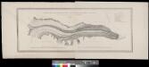
Carte du glacier inférieur de l'Aar
1 : 10000 1 Karte levée en 1842, d'après les directions de M. Agassiz par Jean Wild ; gravée sur pierre par H. Nicolet A. Sonrel, Neuchâtel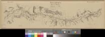
Übersichtsplan der Nord-Rampe
1 : 25000 1 Karte Baugesellschaft Flüelen-Göschenen Hofer, Zürich
Die Canton Uri und Unterwalden
1 : 222000 Švýcarsko
Die Cantone Uri und Unterwalden
1 : 22800 Scheurmann, J.
St. Gotthard
1 Vogelschaukarte Art. Institut Orell Füssli, Zürich
Gotthard
1 : 100000 Eidgenössische Landestopographie
Taschen-Atlas der Schweiz
1 Atlas (25 S., 20 Taf.) gezeichnet und gestochen von Emil Wagner = Atlas de poche de la Suisse : 26 cartes en couleurs / dessinées et gravées par Émile Wagner Eggimann, Genf
Cantone Uri und Unterwalden
1 : 260000 Scheuermann, Johann Jakob Orell, Füssli & Cp.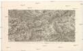
St. Gotthard Gebirge, Theil des Berner Oberlandes und das obere Rhone Thal
Rýn, řeka-tok horní Delkeskamp, F. W. Dauch, J. Ph.