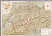
Maps of Switzerland

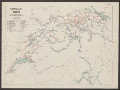
Eisenbahnkarte der Schweiz
1 : 500000 Topogr. Anstalt v. Wurster, Randegger & Co.
Telegraphenkarte der schweizerischen Eisenbahnen
1 : 400000 [s.n.]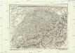
Carte generale de la Suisse suivant ses nouvelles divisions, qui conprennent les ci-devant 13 cantons, leurs alliés et sujets, et forment actuellement la republique Helvetique une et indivisible
1 : 500000 Švýcarsko Mechel, Christian von Chretien de Mechel
Carte générale de la Suisse suivant ses nouvelles divisions, qui comprennent les ci-devant XIII. cantons, leurs alliés et sujets, et forment actuellement la République Helvétique une et indivisible
1 : 510000 Švýcarsko Mechel, Christian von Chretien de Mechel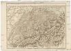
Carte generale de la Suisse suivant ses nouvelles divisions, qui comprennent les ci-devant XIII. cantons, leurs alliés et sujets, et forment actuellement la Republique Helvetique une et indivisible
Švýcarsko Mechel, Christian von Ludvík Chretien de Mechel
Graphisch-statistischer Atlas der Schweizerischen Normalbahnen
1 : 500000 Leistungen des Betriebsmaterials 1881 Schweizerische Nordostbahn Lithographie Druck & Verlag von Hofer & Burger
Graphisch-statistischer Atlas der Schweizerischen Normalbahnen
1 : 500000 Historische Entwicklung der Netze 1875 Schweizerische Nordostbahn Lithographie Druck & Verlag von Hofer & Burger
Graphisch-statistischer Atlas der Schweizerischen Normalbahnen
1 : 500000 Historische Entwicklung der Netze 1855 - 1882 Schweizerische Nordostbahn Lithographie Druck & Verlag von Hofer & Burger
Graphisch-statistischer Atlas der Schweizerischen Normalbahnen
1 : 500000 Historische Entwicklung der Netze 1881 - 1882 Schweizerische Nordostbahn Lithographie Druck & Verlag von Hofer & Burger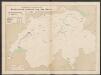
Graphisch-statistischer Atlas der Schweizerischen Normalbahnen
1 : 500000 Historische Entwicklung der Netze 1855 Schweizerische Nordostbahn Lithographie Druck & Verlag von Hofer & Burger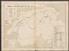
Graphisch-statistischer Atlas der Schweizerischen Normalbahnen
1 : 500000 Historische Entwicklung der Netze 1880 Schweizerische Nordostbahn Lithographie Druck & Verlag von Hofer & Burger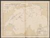
Graphisch-statistischer Atlas der Schweizerischen Normalbahnen
1 : 500000 Historische Entwicklung der Netze 1865 Schweizerische Nordostbahn Lithographie Druck & Verlag von Hofer & Burger
La Suisse
1 : 460000 Švýcarsko Keller, Johann Christoph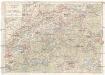
Touristenkarte der Schweiz
1 : 900000 Interlaken (Švýcarsko) Kümmerly & Frey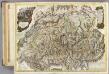
Suisse.
1 : 404000 Faden, William, 1750?-1836
Graphisch-statistischer Atlas der Schweizerischen Normalbahnen
1 : 500000 Ursprüngliche, bis Ende 1881 berechnete Anlagekosten nach Strecken Schweizerische Nordostbahn Lithographie Druck & Verlag von Hofer & Burger
Karte von der Schweiz
1 : 44000 Švýcarsko Reilly, Franz Johann Josef von Faden, William Reilly'schen Landkarten und Kunstwerke Verschleis Komptoir
Carte genérale de la Suisse, oder, Die Helvetische Republik in XXII Cantone eingetheilt
1 : 525000 1 Karte Joh. Walch bei Joh. Walch, Augsburg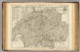
Suisse ou sont les Cantons.
1 : 514000 Merveilleux, David Francois de
Switzerland.
1 : 950400 Johnson, A.J.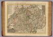
Helvetiae.
1 : 550000 L'Isle, Guillaume de, 1675-1726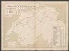
Graphisch-statistischer Atlas der Schweizerischen Normalbahnen
1 : 500000 Historische Entwicklung der Netze 1860 Schweizerische Nordostbahn Lithographie Druck & Verlag von Hofer & Burger
Switzerland.
1 : 1140000 Darton, William
Karte von der Schweiz
1 : 525000 1 Karte Fuessli & Comp., Zürich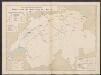
Graphisch-statistischer Atlas der Schweizerischen Normalbahnen
1 : 500000 Historische Entwicklung der Netze 1870 Schweizerische Nordostbahn Lithographie Druck & Verlag von Hofer & Burger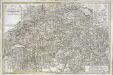
Carte de la Suisse ou l'on a marqué les routes suivies par M.re Wil. Coxe
1 Karte auf 2 Blatt : Kupferdruck ; 45 x 69 cm Coxe s.n.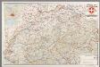
[Recto], uit: Tourist map of Switzerland
1 : 600000 Berne [etc.] : Swiss National Tourist Office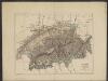
Suisse
1 : 1500000 Dunan, Maurice 1850-1919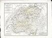
Der Helvetischen Republik neue Cantons und Districts Eintheilung
1 Karte : Typometrie ; 37 x 49 cm Haas Wilhelm Haas