Maps of Gurtnellen
Geologische Uebersichtskarte der Gotthardbahnstrecke
1 : 25000 Blatt 2 Stapff, Friedrich Moritz [s.n.]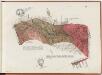
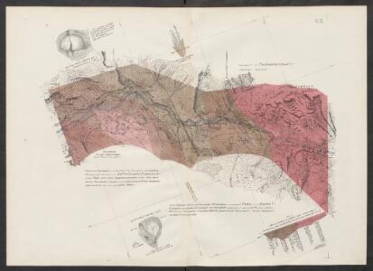
Gotthardbahnstrecke Erstfeld-Castione; geologische Übersichtskarten: Blatt II: Gebiet Silenen-Gurtnellen
1 : 25000 Auftraggebung: Direktion der Gotthardbahn Stapff, F. M., einst Vorstand der geologisch-montanistischen Abteilung bei der Zentralbauleitung der Gotthardbahn Berliner lithogr. Institut, Berlin Druck: J. F. Starke, Berlin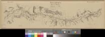
Übersichtsplan der Nord-Rampe
1 : 25000 1 Karte Baugesellschaft Flüelen-Göschenen Hofer, Zürich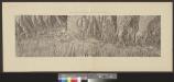
[Gotthardbahnlinie]
1 : 5000 3 Karten von F. Becker ; photolithographisch reduziert auf den Massstab 1:5 000 von Brunner & Hauser Brunner & Hauser, Zürich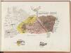
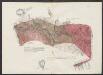
Gotthardbahnstrecke Erstfeld-Castione; geologische Übersichtskarten: Blatt I: Gebiet Erstfeld
1 : 25000 Auftraggebung: Direktion der Gotthardbahn Stapff, F. M., einst Vorstand der geologisch-montanistischen Abteilung bei der Zentralbauleitung der Gotthardbahn Berliner lithogr. Institut, Berlin Druck: J. F. Starke, Berlin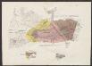
Geologische Uebersichtskarte der Gotthardbahnstrecke
1 : 25000 Blatt 1 Stapff, Friedrich Moritz [s.n.]
Relief pittoresque du sol classique de la Suisse
9 Karten dessiné d'après nature et gravé à l'eau forte par Frédéric Guillaume Delkeskamp ; terminé à l'aqua tinta par François Hegi et J.J. Sperli à Zuric = Malerisches Relief des klassischen Bodens der Schweiz / Nach der Natur gezeichnet und radirt von Friedrich Wilhelm Delkeskamp ; in Aqua tinta vollendet von Franz Hegi und J.J. Sperli in Zürich Friedrich Wilhelm Delkeskamp, Frankfurt a/M.
Ursae fluvii primi fontes
1 Karte delineati a Joh. Jacobo Scheuchzer ; Joh. Lud. Ziegler sculp. [Verlag nicht ermittelbar], [Zürich]
Ursae fluvii primi fontes
1 : 66000 1 Karte delineati a Joh. Jacobo Scheuchzer [Verlag nicht ermittelbar], [Erscheinungsort nicht ermittelbar]
Canton Uri sive Pagus Helvetiae Uriensis cum subditis suis in Valle Lepontina recenter delineatus
1 : 60000 Mollova mapová sbírka Walser, Gabriel Dorn, Sebastian Homann, Johann Baptista - dědici
Pagus Helvetiae Uriensis Cum subditis suis in Valle Lepontina accuratissima
1 : 50000 Mollova mapová sbírka Walser, Gabriel Lotter, Tobias Conrad Seutter, Matthäus
Pagus helvetiæ Uriensis cum subditis suis in Valle Lepontina accuratissima delineatio
1 Karte : Kupferdruck ; 56 x 48 cm Walser; Seutter; Lotter Matthäus Seutter
Relief pittoresque du sol classique de la Suisse
9 Karten dessiné d'après nature et gravé à l'eau forte par Frédéric Guillaume Delkeskamp ; terminé à l'aqua tinta par François Hegi et J.J. Sperli à Zuric = Malerisches Relief des klassischen Bodens der Schweiz / Nach der Natur gezeichnet und radirt von Friedrich Wilhelm Delkeskamp ; in Aqua tinta vollendet von Franz Hegi und J.J. Sperli in Zürich Friedrich Wilhelm Delkeskamp, Frankfurt a/M.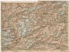
[Andermatt und Umgebung]
1 : 250000 Alpy švýcarské (pohoří) Wagner & Debes
Pagus Helvetiae Uriensis cum subditis suis in valle Lepontina accuratissima delineatio
1 : 116800 Seutter, Matthäus Lotter, Tobias Conrad sumptibus Matthaei Seutteri
Ursae fluvii primi fontes
1 : 66000 1 Karte delineati à Joh. Jacobo Scheuchzer excudit Petrus van der Aa, Lugd. Bat. [i.e. Leiden]
Ursae flvvii primi fontes delineati
1 Karte : Kupferdruck ; 47 x 31 cm Scheuchzer; Ziegler s.n.
Ursae fluvii primi fontes delineati
1 Karte : Kupferdruck ; 40 x 30 cm Scheuchzer apud J. Cóvens et C. Mortier
Excursions-Karte des Schweizer Alpen-Club für den Sommer 1863
1 : 100000 [s.n.]
Karte eines Theiles von Unterwalden und Uri
Leuzinger, Rudolf R. Leuzinger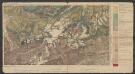
Tödi-Windgällen-Gruppe
1 : 100000 Heim, Albert Wurster & Randegger & Cie.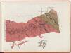
Gotthardbahnstrecke Erstfeld-Castione; geologische Übersichtskarten: Blatt III: Gebiet Wassen-Andermatt
1 : 25000 Auftraggebung: Direktion der Gotthardbahn Stapff, F. M., einst Vorstand der geologisch-montanistischen Abteilung bei der Zentralbauleitung der Gotthardbahn Berliner lithogr. Institut, Berlin Druck: J. F. Starke, Berlin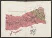
Geologische Uebersichtskarte der Gotthardbahnstrecke
1 : 25000 Blatt 3 Stapff, Friedrich Moritz [s.n.]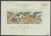
Geologische Karte der Windgällen-Kette
1 : 50000 Schmidt, Carl Wurster, Randegger & Co.
Karte der Terrassen u. Thalstufen des Reussgebietes
1 : 100000 1 Karte von Albert Heim ; [Kartogr.:] Topogr. Anstalt v. Wurster, Randegger & Co. [Verlag der Expedition des Jahrbuches des S.A.C.], [Bern]
Canton Uri sive pagus Helvetiae Uriensis cum subditis suis in Valle Lepontina
1 Karte : Kupferdruck ; 45 x 54 cm Walser; Dorn edentibus Homannianis Heredibus
Canton Uri sive pagus Helvetiae Uriensis cum subditis suis in Valle Lepontina
1 Karte : Kupferdruck ; 45 x 54 cm Walser; Dorn edentibus Homannianis Heredibus
Canton Uri
1 : 100000 Müllhaupt, Hans Heinrich Eidg. Stabsbureau
Generalkarte der Gotthardbahn
1 : 100000 Nordblatt im Verlag von Orell Füssli & Co.