Maps of Mozambique

Spezial-Karte von Afrika
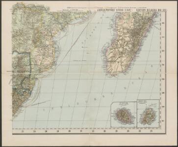
1 : 4000000 Blatt 10 Habenicht, Hermann Perthes
Spezial - karte von AfricaSektion Delacoa Bai (10)
1 : 4000000 1 full d'1 mapa en 10 fulls i estoig Hermann Habenicht; Justus Perthes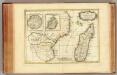
Afrique, cote orientale.
1 : 7000000 Bonne, Rigobert, 1727-1794
INSVLA S. LAVRENTII, | Vulgo | MADAGASCAR.
[Amsterdam : Joan Blaeu]
Madagascar. Carte géologique et minière
1 : 3500000 Madagascar. Service géographique [Tananarive] : Serv[ice] géog[raphique] de Madag[ascar]
Map of Portuguese East Africa
1 : 3000000 Afrika východní Mining and Industrial Publications of Africa
Madagascar.
1 : 2661120 Stanford, Edward
Madagascar
Vidal de La Blache, Paul
Topographical map of the Island of Madagascar
1 : 4580000 from the original design drawn on the spot by M. Roberts S.I. Neele sculpt. London : [s.n.]
Carte Particuliere De L'Isle Dauphine ou Madagascar Et St. Laurens, Levée Par Ordre Expres des Roys De Portugal sous qui on en a Fait la Decouverte. [Karte], in: Atlas nouveau, contenant toutes les parties du monde [...], Bd. 2, S. 225.
1 Karte aus Atlas Sanson, Nicolas Jaillot, Alexis Hubert und Mortier, Pieter
Madagaskar
1 : 4000000 Annotatie geografische gegevens: Aangegeven zijn Franse en Engelse scheepvaartroutes Glogau : Carl Flemming
Carte des missions catholiques à Madagascar
1 : 1776000 [Lyon : Oeuvre de la propagation de la foi]
Géodésie de Madagascar. Triangulation de 1898
1 : 2500000
Géodésie de Madagascar. Triangulation de 1895 à 1900
1 : 2500000
Géodésie de Madagascar. Triangulation de 1899
1 : 2500000
Géodésie de Madagascar. Triangulation antérieure à 1898
1 : 2500000
Géodésie de Madagascar. Triangulation de 1900
1 : 2500000
Madagascar
1 : 5500000 Madagaskar Service géographique
Madagascar, carte hypsométrique
1 : 3500000 Madagascar. Service géographique [Tananarive] : Service géographique du Corps d'occupation
Madagascar, carte hydrographique
1 : 3500000 Madagascar. Service géographique [Tananarive] : Service géographique du Corps d'occupation
Madagascar, carte forestière
1 : 3500000 Madagascar. Service géographique [Tananarive] : Service géographique du Corps d'occupation
Madagascar, carte d'ensemble
1 : 3500000 Madagascar. Service géographique [Tananarive] : Service géographique du Corps d'occupation
Madagascar, carte minière
1 : 3500000 Madagascar. Service géographique [Tananarive] : Service géographique Corps d'occupation
Carte de l'ile de Madagascar
1 : 4500000 réd. par B.F. Leguével de la Combe d'après ses reconnaissances, ses itinéraires, et les cartes du Depôt de la Marine dressée par A. H. Dufour ; la topographie par Felix Charpentier ; la lettre par Ch. Simon Paris : chez Desessart
Carte de Madagascar / publiée par le Service Géographique de l'Armée
1 : 2000000 Annotatie geografische gegevens: Inzetkrt.: Partie sud de Nosy-Bé. - 1:200.000; Baie de Diego-Suarez. - 1:200.000 Service Géographique de l'Armée [S.l. : Service Géographique de l'Armée]
Mozambique (Limpopo Zanzibar) Scale, 1 : 2,000,000
Mozambique. (Limpopo. Zanzibar.) Scale, 1 : 2,000,000. Compiled at the Royal Geographical Society under the direction of the Geographical Section, General Staff. This map forms part of the collection of maps in a case issued to accompany the Manual of Portuguese East Africa," compiled by the Naval Staff of the Admiralty." London : War Office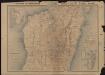
Partie centrale de Madagascar d'après les nouveaux levés et les documents les plus récents
1 : 1000000 Laillet, E. Paris : Augustin Challamel editeur
Tableau d'assemblage de la carte au 1/100 000 de Madagascar
1 : 3500000 Madagascar. Service géographique [Tananarive] : Service géographique de Madagascar
Mocaranga. Afrique 49.
1 : 1641836 Vandermaelen, Philippe, 1795-1869