Maps of Tanzania

Spezial-Karte von Afrika
1 : 4000000 Blatt 8 Habenicht, Hermann Perthes
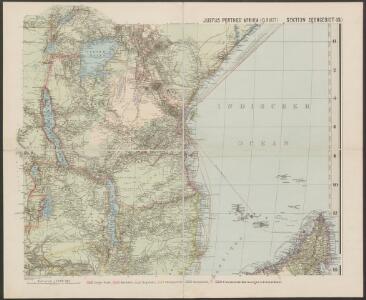
Spezial - karte von AfricaSektion Seengebiet (8)
1 : 4000000 1 full d'1 mapa en 10 fulls i estoig Hermann Habenicht; Justus Perthes
Die Ostküsten süd Africa nebs der Insel Madagascar, den Comoren, Sechellen, Amiranten und Mascarenischen Inseln
1 : 5000000 Komory Weiland, Karl Ferdinand Geograph. Instituts
Deutsch-Ostafrika
1 : 2000000 Afrika východní Moisel, Max Dietrich Reimer
CHARTE von einem Theile der OST-KÜSTE VON Africa
Afrika východní
Charte von einem Theile der Ost-Küste von Africa
Afrika východní
Central Africa - eastern section.
1 : 5000000 John Bartholomew and Son
Originalkarte von Burton's und Speke's Entdeckungen in Innerafrika 1857 u. 1858

Aequatorial-Ost-Afrika
1 : 3000000 Geographische Verlagshandlung Dietrich Reimer
Deutsch-Ostafrika
1 : 2000000 Keňa Rux, W. Just, P. Dietrich Reimer
Wirtschaftskarte von Deutsch-Afrika
1 : 2000000 Afrika východní Uhlig, Carl Moisel, Max Dietrich Reimer
Wirtschaftskarte von Deutsch-Afrika
1 : 2000000 Afrika východní Uhlig, Carl Moisel, Max Dietrich Reimer
Handkarte von Deutsch-Ostafrika
1 : 3000000 Afrika východní Kettler, Julius Iwan Riemer, C. Geographisches Institut
Handkarte von Deutsch-Ostafrika
1 : 3000000 Afrika východní Kettler, Julius Iwan Lindenlaub, A. Geographisches Institut
Handkarte von Deutsch-Ostafrika
1 : 3000000 Afrika východní Kettler, Julius Iwan Lindenlaub, A. Geographisches Institut
Deutsch-Ostafrika
1 : 4000000 Scobel, Albert
Übersichtskarte von Deutsch-Ostafrika
1 : 5000000 Afrika východní Dietrich Reimer
Übersichtskarte von Ost-Central-Afrika

Východní polovice rovníkové Afriky s výzpytnými cestami po suchu a po vodě Henryho Stanleye v letech 1874-1877
1 : 3700000 Afrika střední
Carte des îles Comores
1 : 200000 France. Service géographique des colonies [Paris] : Ministère des Colonies
Karte von Speke's Reisen in Inner-Afrika

Monoemugi. Afrique 40.
1 : 1641836 Vandermaelen, Philippe, 1795-1869
Zindgibar. Afrique 43.
1 : 1641836 Vandermaelen, Philippe, 1795-1869
Mombasa-Victoria (Uganda) Railway and Busoga Railway
Mombasa--Victoria (Uganda) Railway and Busoga Railway. Scale, 1 : 1,500,000 or 1 inch = 23.67 miles.
Daressalam. German East Africa in 9 sheets, Sheet 6

Karte des Forschungs-Gebietes der Graf Samuel Telekíschen Expedition in Ost-Afrika 1887-88
1 : 1000000 Afrika východní Höhnel, Ludwig von Alfred Hölder
Kilimanjaro. Sheet 3.

Partie de Madagascar. Afrique 55.
1 : 1641836 Vandermaelen, Philippe, 1795-1869
Versuch einer geologischen Karte des Njassagebietes
1 : 1000000 Annotatie: Bijlage (Krt. 1) bij: Mitteilungen aus den deutschen Schutzgebieten, Erganzungheft Nr. 10 (1914) Berlin : Mittler