Maps of St. Leonhard im Pitztal

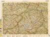
Oetzthal & Stubai
1 : 50000 Nordwest-Blatt Simon, Simon Deutscher u. Oesterreichischer Alpen-Verein
Oetzthal & Stubai

Landeck.
from Spezialkarte der osterreichisch-ungarischen Monarchie.
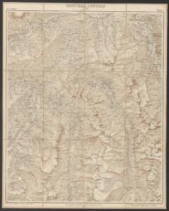
Karte der centralen Ötzthalergruppe
1 : 50000 Ötztalské Alpy (Itálie a Rakousko : pohoří) Haushofer, Karl Hoffmann, Carl Deutscher und Oesterreichischer Alpenverein
Wildspitze
1 : 50000 Východní Alpy (pohoří) Haushofer, Karl Hoffmann, Carl J. Lindauer'sche Buchhandlung
Wildspitze
1 : 50000 Východní Alpy (pohoří) Haushofer, Karl Hoffmann, Carl Deutscher und Oesterreichischer Alpenverein
Glockthurm
1 : 50000 Východní Alpy (pohoří) Haushofer, Karl Hoffmann, Carl J. Lindauer'sche Buchhandlung
Glockthurm
1 : 50000 Východní Alpy (pohoří) Haushofer, Karl Hoffmann, Carl Deutscher und Oesterreichischer Alpenverein
Uebersichtskarte des Oetzthaler Gletscher-Gebietes
1 : 144000 Ötztalské Alpy (Itálie a Rakousko : pohoří) Berghaus, Hermann Sonklar, Karl von Justus Perthes
Uebersichts-Karte des Oetzthaler Gletscher-Gebietes
1 : 144000 Sonklar von Innstädten, Carl ; Berghaus, Hermann Justus Perthes
Nördl. Oetzthaler- und Stubaier Alpen, Nordwest. Kalkalpen
1 : 130000 Alpy rakouské (pohoří) Maschek, R. Meuer, Julius Artaria
Nördl. Oetzthaler- und Stubaier Alpen, nordwest. Kalkalpen
1 : 130000 Meurer, Julius ; Maschek, R. Verlag Artaria & Co.
[Stubaier Alpen]
1 : 100000 Stubaiské Alpy (Itálie a Rakousko : pohoří) Freytag & Berndt
Wandkarte der Schweiz
1 : 200000 1 Karte auf 8 Blättern J.M. Ziegler Wurster, Winterthur
Innsbruck 157, uit: Special-Karte von Mittel-Europa / nach amtlichen Quellen bearbeitet von W. Liebenow
1 : 300000 titelvariant: W. Liebenow's Mittel-Europa; Annotatie: Titel boven de bladen: W. Liebenow's Mittel-Europa Johannes Wilhelm Liebenow 1822-1897 Frankfurt a. M. : Ludwig Ravenstein
194. Mittenwald, uit: Topographische Uebersichtskarte des Deutschen Reiches / herausgegeben v. d. Kartogr. Abt. d. Königl. Preuß. Landesaufnahme
1 : 200000 titelvariant: Topogr. Übersichtskarte des Deutschen Reiches; Annotatie: Titel boven bladen ook: Topogr. Übersichtskarte des Deutschen Reiches; Annotatie geografische gegevens: Op elk blad twee maatstokken: 10 Kilometer = 5,5 cm; 1 geogr. Meile = 3,6 cm; Legenda onder op elk blad Königlich Preußische Landesaufnahme. Kartographische Abtheilung [S.l : Königlich Preußische Landesaufnahme, Kartographische Abtheilung]
Otzthal.
from Spezialkarte der osterreichisch-ungarischen Monarchie.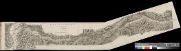
Karte der Arlbergbahn und Rheinthalbahn
1 : 100000 2 Karten zusammengestellt und gezeichnet von P. Rheinberger Orell Füssli, Zürich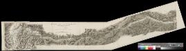
Karte der Arlbergbahn und Rheinthalbahn
1 : 100000 2 Karten zusammengestellt und gezeichnet von P. Rheinberger Orell Füssli, Zürich
Per Inclyti Circuli Suevici Supremorum Ordinum
1 : 160000 Mollova mapová sbírka Pfeffel, Johann Andreas Homann, Johann Baptista - dědici
Per Inclyti Circuli Suevici Supremorum Ordinum :
1 : 160000 Mollova mapová sbírka Pfeffel, Johann Andreas Pfeffel, Johann Andreas I.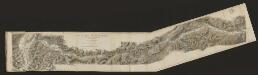
Karte der Arlbergbahn und Rheintalbahn
1 : 100000 Arlberg Rheinberger, P. Orell Füssli & Co.
Nauders.
from Spezialkarte der osterreichisch-ungarischen Monarchie.
Geographica Provinciarum Sveviae Descriptio =
Mollova mapová sbírka Hurter, Johann Christoph Bodenehr, Gabriel
Skiroutenkarte der Ötztaler Alpen
1 : 50000 Ötztalské Alpy (Itálie a Rakousko : pohoří) Kuntscher, Karl Artaria
Geographica Provinciarum Sveviae Descriptio =
Mollova mapová sbírka Hurter, Johann Christoph Bodenehr, Johann Georg
Solden und St. Leonhard (Tirol).
from Spezialkarte der osterreichisch-ungarischen Monarchie.
Lech Tal.
from Spezialkarte der osterreichisch-ungarischen Monarchie.
Oetzthal & Stubai
1 : 50000 Südost-Blatt Simon, Simon Deutscher u. Oesterreichischer Alpen-Verein