Maps of Caucasus Mountains

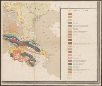
Geologičeskaja karta Evropejskoj Rossii
1 : 2500000 Südost-Blatt Karpinskij, A.P. (Aleksandr Petrovič) Kartografičeskoe zavedenie A.Il'ina
Charte der Laender am Caucasus nach den besten vorhandenen
1 : 2100000 Reinecke, J. C. M. (Johann Christoph Matthias), 1770-1818 Im Verlage des Industrie Comptoirs
Uebersichts Karte der Russischen Provinzen nördlich und südlich vom Kaukasus
1 : 2500000 München : in der literarisch artistischen Anstalt
Uebersichts Karte der russischen Provinzen nördlich und südlich vom Kaukasus
1 : 2900000 1 Karte : Kupferdruck ; 42 x 47 cm in der literarisch artistischen Anstalt
73-74. Caucasia, Mar Caspio.
1 : 3000000 Touring club italiano
Uebersichts Karte der russischen Provinzen nördlich und südlich vom Kaukasus
1 : 2900000 Kavkaz (pohoří : oblast) Literarisch artistische Anstalt
Russia 9.
1 : 3421400 Letts, Son & Co.
Russia in Europe Part IX and Georgia.
1 : 3500000 Society for the Diffusion of Useful Knowledge (Great Britain)
Russia in Europe part IX and Georgia / published under the superintendence of the Society for the Di
1 : 3500000 1 Karte : Kupferdruck ; 31 x 38 cm Walker, John by Baldwin and Cradock
Russia at the Caucasus.
1 : 3380000 Sharpe, J.
Charte générale du pays entre les mers Noire et Caspienne
1 : 2300000 Kaspické moře-oblast Darmet, J. M. T. Mollo
Friedensdislokation im europäischen Russland
1 : 3125000 Kavkaz-oblast
No.29. Karta Evropeyskaia Rossiia. Sheet 15
1 : 2000000 Shokalskago,Iu. M.
Carte générale du pays entre les mers Noire et Caspienne
1 : 2300000 Kaspické moře-oblast Darmet, J.M. Damas, Ange Hyacinthe Maxence de
[Tertia Asie tabula] [Karte], in: Clavdii Ptholomei Viri Alexandrini Cosmographie, S. 170.
1 Karte aus Atlas Nicolaus Germanus [und Ptolemaeus, Claudius]
Höhenschichtenkarte der Kaukasusländer mit Reiserouten Dr. G. Raddes
1 : 4500000 Radde, Gustav Engelmann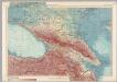
U.S.S.R. - Caucasia. Pergamon World Atlas.
1 : 2500000 Polish Army Topography Service
Pays du Caucase
Nouvel atlas physique politique et historique de l'Empire ottoman et des états limitrophes en Europe, en Asie et en Afrique, en quarante feuilles Hellert, J.J. Bellizard, Dufour et Cie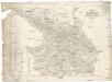
Karte des Kaukasus
Kavkaz-oblast Mahlmann, H. bei F.H. Morin
Charte der Laender am Caucasus
1 : 2200000 Kavkaz-oblast Reinecke, Johann Christoph Matthias
Charte der Laender am Caucasus
1 : 2200000 Kavkaz-oblast Reinecke, Johann Christoph Matthias
Die Völker des Kaukasus, Grusien's und des Armenischen Hochlandes
Zweiter Band, enthaltend in vier Abtheilungen die Vertheilung der Organismen: 5. Pflanzen-Geographie, 6. Thier-Geographie, 7. Anthropographie, 8. Ethnographie Humboldt, Alexander von Verlag von Justus Perthes
Die Völker des Kaukasus u.s.w. / gezeichnet u. gestochen in der geogr. Kunstschule zu Potsdam
1 : 2900000 1 Karte : Kupferdruck ; 31 x 39 cm Berghaus, Heinrich Karl Wilhelm J. Perthes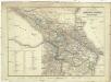
Karta Rossijskich vladěnij za Kavkazom
1 : 1680000 Kavkaz-oblast Kolokolov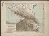
Karte für die Niederschlagsverhältnisse und die Verbreitung der wichtigsten Holzgewächse in den Kaukasusländern
1 : 4500000 Radde, Gustav Engelmann
Die Volker des Kaukasus U.S.W.
1 : 3000000 Berghaus, Heinrich
Kaukasus.
1 : 2600000 Grassl, J. (Joseph)
Sbornyje list 5-ti verstnoj karty Kavkaza
1 : 1778000 Kavkaz (pohoří : oblast)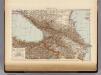
Caucasus.
1 : 3500000 Andree, Richard; Times (London, England)
Nova et accuratissima maris Caspii hactenus maximam partem nobis non satis cogniti ac regionum adjac
1 : 2100000 1 Karte : Kupferdruck ; 48 x 56 cm Seutter, Matthäus [Seutter]