Maps of Teltow-Fläming

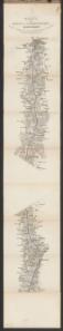
Karte der Berlin-Anhaltischen Eisenbahn
1 : 200000 Verlag von Simon Schropp & Cop.
Praefecturae principatus querfurtensis Dahmiana et Iüterboccensis cum vicinia oppidis, vicis, pagis accurate distincta
1 : 130000 Braniborsko (Německo) Seutter, Matthäus Lotter, Tobias Conrad M. Seutter
Accurate Geographische Delineation Derer Zum Fürstenthum Querfurth gehörigen zwey Aemmter Dahme und Jüterbog
1 : 120000 Mollova mapová sbírka Schenk, Pieter Schenk, Peter II
Praefecturae Principatus Querfurtensis Dahmiana Et Iüterboccensis
1 : 120000 Mollova mapová sbírka Lotter, Tobias Conrad Seutter, Matthäus
Carte Geographique, ou on fait voir le Dvche de Saxonie nome. le Cercle Electorale :
1 : 110000 Mollova mapová sbírka Homann, Johann Baptist Homann, Johann Baptista - dědici
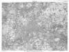
Geologische Übersichtskarte der Umgegend von Berlin
1 : 100000 Berendt, G. ; Laufer, E. Lithogr. Institut
Der Teltowische Creis
1 : 300000 Oesfeld, Karl Ludwig von Jättnig, Karl
86. Berlin, Districts of Leipzig, Dresden, Karl-Marx-Stadt. The World Atlas.
1 : 1250000 USSR (Union of Soviet Socialist Republics).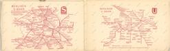
Taschenplan von Berlin
Berlin (1944)
Germany. Berlin. Scale, 1: 59,000 (approx.). Copied from a German map dated 1931. G.S.G.S. (Misc.) No.168. [London] : War Office
Berlin unter alliierter Verwaltung 1.9.1945
Berlin Kunz, Andreas ; Moeschl, Joachim Robert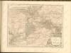
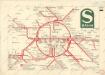
S Bahn

Composite: 317. Luckenwalde.
1 : 100000 Reichsamt fur Landesaufnahme
Umgebung von Berlin

317. Luckenwalde.
1 : 100000 Reichsamt fur Landesaufnahme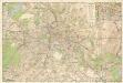
Strassenübersichtsplan von Berlin

Neuer geometrischer Plan der gesammten königlich-preussischen und churfürstlich-brandenburgischen Haupt und Rezidnez Stadt Berlin
1 : 79000 Berlín (Německo) Lotter, Tobias Conrad Tobias Conrad Lotter
Grundriss von Berlin
Berlín (Německo) Herzberg Veit Veit et Comp.
Blatt X Zossen, uit: Karte von Berlin und Umgebung in 12 Blättern
1 : 50000 Annotatie: Toelichtingen opgeborgen bij kaart; Annotatie geografische gegevens: Met schaalstokken: Meter, Schritt, geographische Meile Paul Schneider Berlin : Reichsamt für Landesaufnahme
Blatt VI Berlin, uit: Karte von Berlin und Umgebung in 12 Blättern
1 : 50000 Annotatie: Toelichtingen opgeborgen bij kaart; Annotatie geografische gegevens: Met schaalstokken: Meter, Schritt, geographische Meile Paul Schneider Berlin : Reichsamt für Landesaufnahme
Großer Silva-Stadtplan von Berlin
1 : 23000 Berlín (Německo) Verlag für heimatliche Kultur Willy Holz
Composite: 293. Potsdam.
1 : 100000 Reichsamt fur Landesaufnahme
293. Potsdam.
1 : 100000 Reichsamt fur Landesaufnahme
268. Spandau.
1 : 100000 Reichsamt fur Landesaufnahme
Blatt IX Werder, uit: Karte von Berlin und Umgebung in 12 Blättern
1 : 50000 Annotatie: Toelichtingen opgeborgen bij kaart; Annotatie geografische gegevens: Met schaalstokken: Meter, Schritt, geographische Meile Paul Schneider Berlin : Reichsamt für Landesaufnahme
Blatt V Potsdam, uit: Karte von Berlin und Umgebung in 12 Blättern
1 : 50000 Annotatie: Toelichtingen opgeborgen bij kaart; Annotatie geografische gegevens: Met schaalstokken: Meter, Schritt, geographische Meile Paul Schneider Berlin : Reichsamt für Landesaufnahme
Composite: 268. Spandau.
1 : 100000 Reichsamt fur Landesaufnahme
318. Zossen.
1 : 100000 Reichsamt fur Landesaufnahme