Maps of Europe

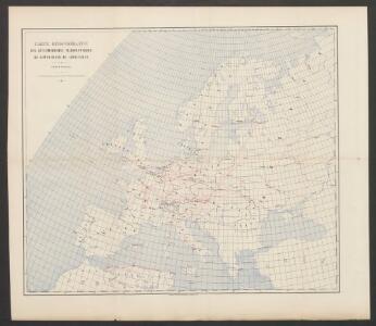
Carte demonstrative des déterminations télégraphiques de différences de longitudes
1 : 10000000 Institut topographique militaire
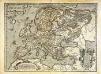
Nova et accurate divisa in regna et regiones praecipuas Europae descriptio
1 : 10000000 per F. de Witt Amstelodami [Amsterdam] : ex officina I. Cóvens et C. Mortier
Carte demonstrative des determinations astronomiques de latitude et d'azimuth
1 : 10000000 Institut topographique militaire
Nova Europae Descriptio [Karte], in: Gerardi Mercatoris Atlas, sive, Cosmographicae meditationes de fabrica mundi et fabricati figura, S. 64.
1 Karte aus Atlas Mercator, Gerhard Montanus, Petrus
Karte von Europa und dem Mittelländischen Meere
1 : 4300000 Evropa Stülpnagel, Friedrich von Bär, Johann Christoph Justus Perthes
Karte von Europa und dem Mittelländischen Meere
1 : 4300000 Evropa Stülpnagel, Friedrich von Bär, Johann Christoph Justus Perthes
Europa delineata et recens edita per Nicolaum Visscher. [Karte], in: Novus atlas absolutissimus, Bd. 1, S. 28.
1 Karte aus Atlas Janssonius Offizin
Europa 1881
Europa Kunz, Andreas ; Röss, Wolf ; Moeschl, Joachim Robert
Europa
1 : 12000000 Evropa Kiepert, Heinrich Bishoff, C. Geographische Verlagshandlung Dietrich Reimer
Europa.
1 : 38000000 Flemming, Carl
L'Evrope
1 Karte : Kupferdruck ; 37 x 49 cm Jaillot; Berey chez H. Iailliot proche les Augustins
Nova Europae descriptio
1 Karte : Kupferdruck ; 44 x 54 cm Danckerts Danckerts
Europa
1 Karte : Kupferdruck ; 33 x 45 cm Merian Matthäus Merian
Europe : laid down from the observations of the Royal Academy of Sciences & compared with the maps of Sanson, Nolin, Du Fer, De l'Isle, Moll & other modern geographers ... / [John Bowles] ; engrav'd by Emanuel Bowen
1 : 4500000 Annotatie: Met tabel van Europese lengtematen; Met informatie over de verschillende Europese staten Bowles, John; Bowen, Emanuel London : printed for John Bowles
Europa nach seinen kirchlichen Verhältnissen im Mittelalter
1 : 15000000 Europa Kirchengeschichte
48. West Europe, Communications. The World Atlas.
1 : 12500000 USSR (Union of Soviet Socialist Republics).
Europa

Europa
1 Karte : Kupferdruck ; 45 x 53 cm Götze im Verlage des Geograph: Instituts
Europa
1 Karte : Kupferdruck ; 45 x 55 cm Götze im Verlage des Geograph. Instituts
Europa
1 Karte : Kupferdruck ; 46 x 54 cm Götze im Verlage des Geograph. Instituts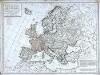
Carte politique de l'Europe
1 Karte : Kupferdruck ; 50 x 68 cm Poirson; Jean; Brion de la Tour chez Jean rue Jean de Beauvais no. 10
Carte politique hydrographique [et] routiere de l'Europe
1 Karte : Kupferdruck ; 48 x 54 cm Champion; Hinrichs chez J. C. Hinrichs libraire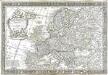
L'Europe
1 Karte : Kupferdruck ; 43 x 66 cm Nolin; Boniselle; Jean chez Jean rue Jean de Beauvais no. 32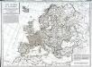
Carte politique de l'Europe
1 Karte : Kupferdruck ; 50 x 68 cm Poirson; Jean; Brion de la Tour chez Jean rue Jean de Beauvais no. 32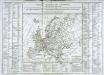
Tableau général de l'Europe
1 Karte : Kupferdruck ; 35 x 44 cm, Bildgrösse: 52 x 73 cm Brion de la Tour; Le Campion; Le Campion chés les Campion freres m.ds d'estampes rue St. Jacques près la f.e S. Severin à la ville de Rouen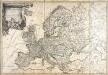
L'Europe
1 Karte : Kupferdruck ; 49 x 73 cm Brion de la Tour; Esnault; Rapilly chez Esnauts et Rapilly rue St. Jacques à la ville de Coutances
Europa 1964
Europa Kunz, Andreas ; Moeschl, Joachim Robert

Evropam; sive Celticam veterem
1 Karte : Kupferdruck ; 34 x 46 cm Ortelius; Hamersvelt s.n.