Maps of Germany

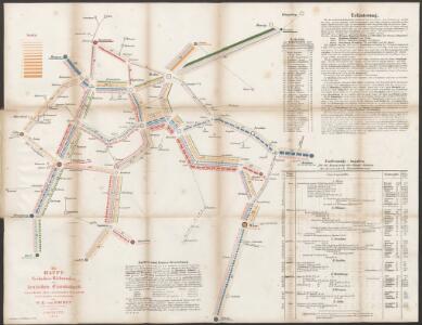
Die Haupt-Verkehrs-Richtungen auf deutschen Eisenbahnen hinsichtlich ihrer merkantilen Bedeutung durch Farben veranschaulicht
1 : 2000000 Loeben, W.K. von Weingartner
Neueste Post-Karte von Deutschland und den angrenzenden Laendern
1 : 1700000 Maďarsko Mollo, Tranquillo T. Mollo
(Villes Anseatiques)
1 : 2900000 Dangeau, abbe de, 1643-1723
Mittelbach's Automobilkarte von Mitteleuropa
1 : 1500000 Evropa střední Mittelbach's Verlag
Europe Centrale.
1 : 3500000 Levasseur, E.
Die deutsche Bundesstaaten
1 : 3500000 Evropa střední Raffelsperger, Franz in Typographischen Landkarte-Verlage
L'empire d'Allemagne
1 Karte auf 2 Blatt : Kupferdruck ; 72 x 103 cm Brion de la Tour; Longchamps chés Longchamps géographe rue St. Jacques à l'enseigne de la place des Victoires
Rand McNally Popular map of Germany and Hungary
1 : 3992000 Rand McNally & Company
Velkoněmecká říše, Protektorát Čechy a Morava, Gen.- Guvernement, Slovensko a Švýcarsko
Deutschland nach seiner neuesten Grenz-Berichtigung
1 : 2350000 Evropa střední Mollo, Tranquillo T. Mollo
Deutschland nach seiner neuesten Grenz-berichtigung
1 : 2350000 Evropa střední Mollo, Tranquillo T. Mollo
Deutschland nach seiner neuesten Grenz-Berichtigung
1 : 2370000 Evropa střední Mollo, Tranquillo bey T. Mollo
Germania Antiqua.
1 : 2300000 Robert de Vaugondy, Gilles, 1688-1766
Neueste Post Karte von Deutschland und dessen angrenzenden Länder
Evropa střední Jättnig, Karl Simon Schropp
Empire d'Allemagne, Hongrie, Gallicie, Prusse, Provinces-Unies de Pays-Bas; en 1789.
1 : 3500000 Brue, Adrien Hubert, 1786-1832
CARTE de L'ALLEMAGNE POLITIQUE ACTUELLE a partir du CONGRES de VIENNE ou CONFÉDÉRATION GERMANIQUE, renfermant occasionellement la CONFÉDÉRATION SUISSE
Německo Hacq P. Renouard
Germany
1 : 4200000 Německo
Germania magna, Rhaetia, Noricum
1 : 3800000 Evropa střední Spruner, Karl von Behrens, W. Justus Perthes
Neueste Post Karte von ganz Deutschland
1 : 1460000 Evropa střední Müller, Franz Artaria
Imperii romano-germanici in suos status et circulos divisi tabula generalis
1 : 1750000 Ultraject : edita per Cornelium Kribber
Germany, Austria, and Switzerland.
1 : 4100000 Gray, Ormando Willis
L'Allemagne 843 a 911.
1 : 6300000 Houze, Antoine Philippe
Germany.
1 : 6400000 Tanner, Henry S.
Geschäfts- und Reise-Tableau für Deutschland und die angränzenden Länder
1 : 3620000 Německo Seitz, Johan Baptista Ioh. Bapt. Seitz
Velkoněmecká Říše
Neueste und vollstaendigste Post Karte von ganz Deutschland Niederlanden Schweiz Pohlen Ungarn und den angränzenden Theilen Frankreichs u Italien
Evropa střední Cappi, Jean Jean Cappi
Střední Evropa
1 : 4500000 Evropa střední
Střední Evropa
1 : 4500000 Evropa střední
La Germanie 741 a 843.
1 : 6300000 Houze, Antoine Philippe