Maps of Bílovec

Wischkowitz (Wysskowske) - m3525-1-001 - Kaiserpflichtexemplar der Landkarten des stabilen Katasters
1 : 2880
Wischkowitz (Wysskowske) - m3525-1-002 - Kaiserpflichtexemplar der Landkarten des stabilen Katasters
1 : 2880
Wischkowitz (Wysskowske) - m3525-1-003 - Kaiserpflichtexemplar der Landkarten des stabilen Katasters
1 : 2880
Hrabstwie (Hrabsky) - m0878-1-001 - Kaiserpflichtexemplar der Landkarten des stabilen Katasters
1 : 2880
Hrabstwie (Hrabsky) - m0878-1-002 - Kaiserpflichtexemplar der Landkarten des stabilen Katasters
1 : 2880
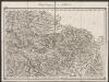
Karte der Umgebung von Troppau

Tžieschkowitz (Tžiesskowice) - m3104-1-001 - Kaiserpflichtexemplar der Landkarten des stabilen Katasters
1 : 2880
Tžieschkowitz (Tžiesskowice) - m3104-1-003 - Kaiserpflichtexemplar der Landkarten des stabilen Katasters
1 : 2880
Tžieschkowitz (Tžiesskowice) - m3104-1-002 - Kaiserpflichtexemplar der Landkarten des stabilen Katasters
1 : 2880
Tžieschkowitz (Tžiesskowice) - m3104-1-004 - Kaiserpflichtexemplar der Landkarten des stabilen Katasters
1 : 2880
Tžieschkowitz (Tžiesskowice) - m3104-1-005 - Kaiserpflichtexemplar der Landkarten des stabilen Katasters
1 : 2880
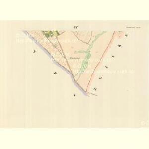
Schlatten (Slatina) - m2757-1-004 - Kaiserpflichtexemplar der Landkarten des stabilen Katasters
1 : 2880
Schlatten (Slatina) - m2757-1-002 - Kaiserpflichtexemplar der Landkarten des stabilen Katasters
1 : 2880
Schlatten (Slatina) - m2757-1-003 - Kaiserpflichtexemplar der Landkarten des stabilen Katasters
1 : 2880
Schlatten (Slatina) - m2757-1-001 - Kaiserpflichtexemplar der Landkarten des stabilen Katasters
1 : 2880
Schlatten (Slatina) - m2757-1-005 - Kaiserpflichtexemplar der Landkarten des stabilen Katasters
1 : 2880
[Kartenblatt]
1 : 25000 Bílovec (Česko : oblast) Reichsamt für Landesaufnahme
Karte der Umgebung von Troppau

III. vojenské mapování 4060
1 : 75000
III. vojenské mapování 4060
1 : 75000
Opava a Moravská Ostrava
1 : 75000 Opava (Česko : oblast) Vojenský zeměpisný ústav
Opava a Moravská Ostrava
1 : 75000 Opava (Česko : oblast) Vojenský zeměpisný ústav
Opava
1 : 75000 Bílovec (Česko : oblast) Vojenský zeměpisný ústav
Opava
1 : 75000 Bílovec (Česko : oblast) Kartografické odd. při Min. nár. obrany
Troppau
1 : 75000 Morava (Česko) Schuberth K. u. k. Militärgeographisches Institut
Podrobná mapa Markrabství moravského a Vévodství slezkého
1 : 100000 Bílovec (Česko : oblast) Srp, Jan Jos. R. Vilímek
Podrobná místopisná mapa Království Českého

Troppau
from Spezialkarte der osterreichisch-ungarischen Monarchie.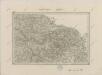
II. vojenské mapování 5
1 : 144000