Maps of Pavlov

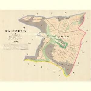
Dwatzetin - m3250-1-001 - Kaiserpflichtexemplar der Landkarten des stabilen Katasters
1 : 2880
Schweine (Swinow) - m2984-1-002 - Kaiserpflichtexemplar der Landkarten des stabilen Katasters
1 : 2880
Schweine (Swinow) - m2984-1-001 - Kaiserpflichtexemplar der Landkarten des stabilen Katasters
1 : 2880
Schweine (Swinow) - m2984-1-005 - Kaiserpflichtexemplar der Landkarten des stabilen Katasters
1 : 2880
Schweine (Swinow) - m2984-1-004 - Kaiserpflichtexemplar der Landkarten des stabilen Katasters
1 : 2880
Schweine (Swinow) - m2984-1-003 - Kaiserpflichtexemplar der Landkarten des stabilen Katasters
1 : 2880
Pawlow - m2239-1-003 - Kaiserpflichtexemplar der Landkarten des stabilen Katasters
1 : 2880
Pawlow - m2239-1-002 - Kaiserpflichtexemplar der Landkarten des stabilen Katasters
1 : 2880
Pawlow - m2239-1-001 - Kaiserpflichtexemplar der Landkarten des stabilen Katasters
1 : 2880
III. vojenské mapování 4158/1
1 : 25000
III. vojenské mapování 4158/1
1 : 25000

Dislocation du regiment de Grunne
1 : 150000 Mohelnice-oblast (Šumperk, Česko) Breye
Grundwasserisohypsen der oberen Marchbeckens
1 : 75000 Hornomoravský úval (Česko)
[Tschechoslowakie, Maßstab 1:75 000]. 4158, Olomouc : sonderausgabe : nur fur den dienstgebrauch
1 : 75000
Olmutz.; Spezialkarte der osterreichisch-ungarischen Monarchie.
from Spezialkarte der osterreichisch-ungarischen Monarchie. Austro-Hungarian Monarchy. Militärgeographisches Institut.,
Geologische Spezialkarte der... Österreichisch-Ungarischen Monarchie... Olmütz

Geologische Spezialkarte der im Reichsrate vertretenen Königreiche und Länder der Österreichisch-Ungarischen Monarchie
1 : 75000 Olomouc (Česko : oblast) Tietze, Emil Ernst August Lipold, Markus Vincenc K. k. geologischen Reichsanstalt
Olmütz
1 : 75000 Loštice (Česko : oblast) Lampe K. u. k. Militärgeographisches Institut
III. vojenské mapování 4158
1 : 75000
Podrobná mapa Markrabství moravského a Vévodství slezkého
1 : 100000 Lanškroun (Česko : oblast) Srp, Jan Jos. R. Vilímek
Vilímkovy místopisné mapy zemí Koruny české
1 : 100000 Lanškroun (Česko : oblast) Srp, Jan Jos. R. Vilímek
Podrobná mapa Království českého, Markrabství moravského a Vévodství slezského
1 : 100000 Lanškroun (Česko : oblast) Srp, Jan Jos. R. Vilímek
Podrobná mapa Království českého
1 : 100000 Lanškroun (Česko : oblast) Srp, Jan Jos. R. Vilímek
Eisenbahn Karte Wien-Dresden, Ollmütz-Trübau
1 : 72000 Blatt 9 Minarzik, Anselm J. Rauh
[Železniční trať Krasíkov-Olomouc]
1 : 60000 Krasíkov (Ústí nad Orlicí, Česko)
Landskorn und Mhr. Trubau.
from Spezialkarte der osterreichisch-ungarischen Monarchie.
II. vojenské mapování 4
1 : 144000
Special - Karte der Markgrafschaft Maehren und des Herzogthums Schlesien