Maps of Stará Ves nad Ondřejnicí

Proskowitz - m2416-1-003 - Kaiserpflichtexemplar der Landkarten des stabilen Katasters
1 : 2880
Proskowitz - m2416-1-001 - Kaiserpflichtexemplar der Landkarten des stabilen Katasters
1 : 2880
Proskowitz - m2416-1-002 - Kaiserpflichtexemplar der Landkarten des stabilen Katasters
1 : 2880
Alt Biela (Stara Biela) - m2836-1-004 - Kaiserpflichtexemplar der Landkarten des stabilen Katasters
1 : 2880
Alt Biela (Stara Biela) - m2836-1-003 - Kaiserpflichtexemplar der Landkarten des stabilen Katasters
1 : 2880
Alt Biela (Stara Biela) - m2836-1-008 - Kaiserpflichtexemplar der Landkarten des stabilen Katasters
1 : 2880
Alt Biela (Stara Biela) - m2836-1-007 - Kaiserpflichtexemplar der Landkarten des stabilen Katasters
1 : 2880
Alt Biela (Stara Biela) - m2836-1-005 - Kaiserpflichtexemplar der Landkarten des stabilen Katasters
1 : 2880
Alt Biela (Stara Biela) - m2836-1-009 - Kaiserpflichtexemplar der Landkarten des stabilen Katasters
1 : 2880
Alt Biela (Stara Biela) - m2836-1-002 - Kaiserpflichtexemplar der Landkarten des stabilen Katasters
1 : 2880
Alt Biela (Stara Biela) - m2836-1-001 - Kaiserpflichtexemplar der Landkarten des stabilen Katasters
1 : 2880
Alt Biela (Stara Biela) - m2836-1-006 - Kaiserpflichtexemplar der Landkarten des stabilen Katasters
1 : 2880
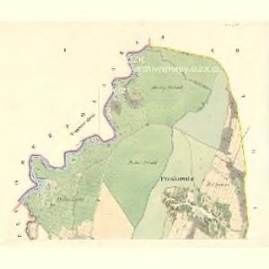
Nieder Pohlanka (Polanka Dulnj) - m0517-1-004 - Kaiserpflichtexemplar der Landkarten des stabilen Katasters
1 : 2880
Nieder Pohlanka (Polanka Dulnj) - m0517-1-002 - Kaiserpflichtexemplar der Landkarten des stabilen Katasters
1 : 2880
Nieder Pohlanka (Polanka Dulnj) - m0517-1-001 - Kaiserpflichtexemplar der Landkarten des stabilen Katasters
1 : 2880
Nieder Pohlanka (Polanka Dulnj) - m0517-1-005 - Kaiserpflichtexemplar der Landkarten des stabilen Katasters
1 : 2880
Nieder Pohlanka (Polanka Dulnj) - m0517-1-003 - Kaiserpflichtexemplar der Landkarten des stabilen Katasters
1 : 2880
Nieder Pohlanka (Polanka Dulnj) - m0517-1-006 - Kaiserpflichtexemplar der Landkarten des stabilen Katasters
1 : 2880

Okresní hejtmanství Moravsko-Ostravské


Moravská Ostrava a okolí

Místek-Frýdek a okolí
1 : 75000 Frýdek-Místek (Česko : oblast) Vojenský zeměpisný ústav
Místek - Frýdek a okolí

Moravská Ostrava a okolí
1 : 75000 Ostrava (Česko : oblast) Vojenský zeměpisný ústav
Příruční mapa okresu Nový Jičín

Podrobná mapa Markrabství moravského a Vévodství slezkého
1 : 100000 Bílovec (Česko : oblast) Srp, Jan Jos. R. Vilímek
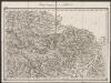
Troppau
from Spezialkarte der osterreichisch-ungarischen Monarchie.
II. vojenské mapování 5
1 : 144000