Maps of Němčice

Niemtschitz - m1976-1-001 - Kaiserpflichtexemplar der Landkarten des stabilen Katasters
1 : 2880
Niemtschitz - m1976-1-002 - Kaiserpflichtexemplar der Landkarten des stabilen Katasters
1 : 2880
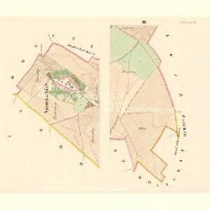
Zobrazení obvodu obce Němčic v soudním okresu Kroměřížském na Moravě před scelováním hospodářských pozemků
1 : 6500 Němčice (Kroměříž, Česko)
Zobrazení obvodu obce Němčic v soudním okresu Kroměřížském na Moravě po provedeném scelení hospodářských pozemků
1 : 6500 Němčice (Kroměříž, Česko)
Altendorf (Starawes) - m2844-1-001 - Kaiserpflichtexemplar der Landkarten des stabilen Katasters
1 : 2880
Altendorf (Starawes) - m2844-1-004 - Kaiserpflichtexemplar der Landkarten des stabilen Katasters
1 : 2880
Altendorf (Starawes) - m2844-1-005 - Kaiserpflichtexemplar der Landkarten des stabilen Katasters
1 : 2880
Altendorf (Starawes) - m2844-1-003 - Kaiserpflichtexemplar der Landkarten des stabilen Katasters
1 : 2880
Altendorf (Starawes) - m2844-1-006 - Kaiserpflichtexemplar der Landkarten des stabilen Katasters
1 : 2880
Altendorf (Starawes) - m2844-1-002 - Kaiserpflichtexemplar der Landkarten des stabilen Katasters
1 : 2880
Prawtschitz - m2404-1-001 - Kaiserpflichtexemplar der Landkarten des stabilen Katasters
1 : 2880
Prawtschitz - m2404-1-003 - Kaiserpflichtexemplar der Landkarten des stabilen Katasters
1 : 2880
Prawtschitz - m2404-1-002 - Kaiserpflichtexemplar der Landkarten des stabilen Katasters
1 : 2880
Prawtschitz - m2404-1-004 - Kaiserpflichtexemplar der Landkarten des stabilen Katasters
1 : 2880
Prawtschitz - m2404-1-005 - Kaiserpflichtexemplar der Landkarten des stabilen Katasters
1 : 2880
Gradkartenblatt
1 : 25000 Kroměříž-oblast (Česko) Catinelli, Max von

Kroměříž a Přerov
1 : 75000 Bystřice pod Hostýnem (Česko : oblast) Vojenský zeměpisný ústav
III. vojenské mapování 4259
1 : 75000
Přerov
1 : 75000 Morava (Česko) Vojenský zeměpisný ústav
Kroměříž a Přerov
1 : 75000 Kroměříž (Česko : oblast) Vojenský zeměpisný ústav
Podrobná místopisná mapa Království Českého

Podrobná mapa Markrabství moravského a Vévodství slezkého
1 : 100000 Moravské markrabství Srp, Jan Jos. R. Vilímek
Podrobná místopisná mapa Království Českého

[Olomouc a okolí]
Prostějov-oblast (Česko) Lepař, Jan Raffelsperger, Franz
Kremsier und Prerau (Mahren).
from Spezialkarte der osterreichisch-ungarischen Monarchie.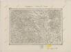
II. vojenské mapování 9
1 : 144000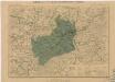
Generální mapa okresních hejtmanství
Umgebungen von Wischau und ungrisch Hradisch
1 : 144000 K.K. Militärisches Geographisches Institut