Maps of Horní Moštěnice

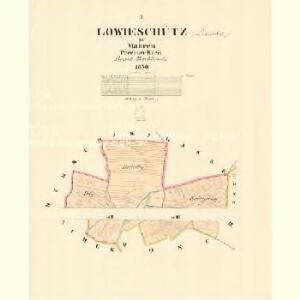
Lowieschütz - m1631-1-002 - Kaiserpflichtexemplar der Landkarten des stabilen Katasters
1 : 2880
Lowieschütz - m1631-1-001 - Kaiserpflichtexemplar der Landkarten des stabilen Katasters
1 : 2880
Moschtienitz - m0803-1-003 - Kaiserpflichtexemplar der Landkarten des stabilen Katasters
1 : 2880
Moschtienitz - m0803-1-001 - Kaiserpflichtexemplar der Landkarten des stabilen Katasters
1 : 2880
Moschtienitz - m0803-1-002 - Kaiserpflichtexemplar der Landkarten des stabilen Katasters
1 : 2880
Moschtienitz - m0803-1-005 - Kaiserpflichtexemplar der Landkarten des stabilen Katasters
1 : 2880
Moschtienitz - m0803-1-006 - Kaiserpflichtexemplar der Landkarten des stabilen Katasters
1 : 2880
Moschtienitz - m0803-1-004 - Kaiserpflichtexemplar der Landkarten des stabilen Katasters
1 : 2880
Gradkartenblatt
1 : 25000 Morava (Česko) Catinelli, Max von


Übersichtskarte der Gegend um Olmütz
Olomouc-oblast (Česko) Domek
Kroměříž a Přerov
1 : 75000 Bystřice pod Hostýnem (Česko : oblast) Vojenský zeměpisný ústav
III. vojenské mapování 4259
1 : 75000
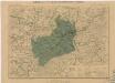
Přerov
1 : 75000 Morava (Česko) Vojenský zeměpisný ústav
Kroměříž a Přerov
1 : 75000 Kroměříž (Česko : oblast) Vojenský zeměpisný ústav
Plan zu den Gefechten bei Biskupitz 14. Juli Tobitschau und Roketnitz 15. Juli 1866
1 : 72000 Biskupice (Prostějov, Česko) Ditfurth, Moritz von des K. u. k. Militärgeographischen Instituts
Plan zu den Gefechten bei Biskupitz 14. Juli Tobitschau und Roketnitz 15. Juli 1866
1 : 72000 Biskupice (Prostějov, Česko)
Podrobná místopisná mapa Království Českého

Podrobná mapa Markrabství moravského a Vévodství slezkého
1 : 100000 Moravské markrabství Srp, Jan Jos. R. Vilímek
Podrobná místopisná mapa Království Českého

Hranice a okolí
1 : 75000 Hranice (Přerov, Česko : oblast) Vojenský zeměpisný ústav
[Olomouc a okolí]
Prostějov-oblast (Česko) Lepař, Jan Raffelsperger, Franz
II. vojenské mapování 9
1 : 144000
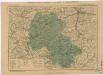
Kremsier und Prerau (Mahren).
from Spezialkarte der osterreichisch-ungarischen Monarchie.
II. vojenské mapování 9
1 : 144000
Hranice a okolí
Generální mapa okresních hejtmanství

Mapa hejtmanství přerovského
Přerov-oblast (Česko) Lepař, Jan Raffelsperger, Franz Ant. Michálek