Maps of Bouzov

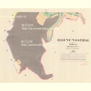
Hofnungsthal - m0548-1-002 - Kaiserpflichtexemplar der Landkarten des stabilen Katasters
1 : 2880
Hofnungsthal - m0548-1-001 - Kaiserpflichtexemplar der Landkarten des stabilen Katasters
1 : 2880
Bezdiekow - m0061-1-002 - Kaiserpflichtexemplar der Landkarten des stabilen Katasters
1 : 2880
Bezdiekow - m0061-1-001 - Kaiserpflichtexemplar der Landkarten des stabilen Katasters
1 : 2880
Busau (Bauzow) - m0193-1-004 - Kaiserpflichtexemplar der Landkarten des stabilen Katasters
1 : 2880
Busau (Bauzow) - m0193-1-003 - Kaiserpflichtexemplar der Landkarten des stabilen Katasters
1 : 2880
Busau (Bauzow) - m0193-1-001 - Kaiserpflichtexemplar der Landkarten des stabilen Katasters
1 : 2880
Busau (Bauzow) - m0193-1-002 - Kaiserpflichtexemplar der Landkarten des stabilen Katasters
1 : 2880
Busau (Bauzow) - m0193-1-005 - Kaiserpflichtexemplar der Landkarten des stabilen Katasters
1 : 2880
Irzmann - m1074-1-001 - Kaiserpflichtexemplar der Landkarten des stabilen Katasters
1 : 2880
Irzmann - m1074-1-002 - Kaiserpflichtexemplar der Landkarten des stabilen Katasters
1 : 2880
Kosow - m1324-1-001 - Kaiserpflichtexemplar der Landkarten des stabilen Katasters
1 : 2880
Kosow - m1324-1-002 - Kaiserpflichtexemplar der Landkarten des stabilen Katasters
1 : 2880
Gradkartenblatt
1 : 25000 Litovel-oblast (Česko) Duré, Friedrich
III. vojenské mapování 4158/1
1 : 25000
III. vojenské mapování 4158/1
1 : 25000
[Kartenblatt]
1 : 25000 Bouzov (Česko : oblast) Reichsamt für Landesaufnahme


Dislocation du regiment de Grunne
1 : 150000 Mohelnice-oblast (Šumperk, Česko) Breye
Grundwasserisohypsen der oberen Marchbeckens
1 : 75000 Hornomoravský úval (Česko)
Olomouc
1 : 75000 Morava (Česko) Vojenský zeměpisný ústav
[Tschechoslowakie, Maßstab 1:75 000]. 4158, Olomouc : sonderausgabe : nur fur den dienstgebrauch
1 : 75000
Olmutz.; Spezialkarte der osterreichisch-ungarischen Monarchie.
from Spezialkarte der osterreichisch-ungarischen Monarchie. Austro-Hungarian Monarchy. Militärgeographisches Institut.,
Geologische Spezialkarte der... Österreichisch-Ungarischen Monarchie... Olmütz

Geologische Spezialkarte der im Reichsrate vertretenen Königreiche und Länder der Österreichisch-Ungarischen Monarchie
1 : 75000 Olomouc (Česko : oblast) Tietze, Emil Ernst August Lipold, Markus Vincenc K. k. geologischen Reichsanstalt
Olmütz
1 : 75000 Loštice (Česko : oblast) Lampe K. u. k. Militärgeographisches Institut
III. vojenské mapování 4158
1 : 75000
Podrobná mapa Markrabství moravského a Vévodství slezkého
1 : 100000 Lanškroun (Česko : oblast) Srp, Jan Jos. R. Vilímek