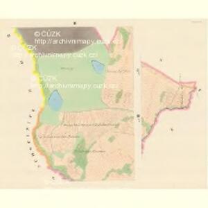
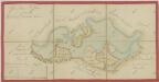
Maps of Žíšov

Zischow - c9453-1-002 - Kaiserpflichtexemplar der Landkarten des stabilen Katasters
1 : 2880
Zischow - c9453-1-004 - Kaiserpflichtexemplar der Landkarten des stabilen Katasters
1 : 2880
Zischow - c9453-1-003 - Kaiserpflichtexemplar der Landkarten des stabilen Katasters
1 : 2880
Zischow - c9453-1-001 - Kaiserpflichtexemplar der Landkarten des stabilen Katasters
1 : 2880
Veselí o. Tábor 1
1 : 2880
Řípec o. Tábor 1
1 : 2880
Mapy činžovních pozemků I. sekce třeboňského velkostatku pro obce: Borkovice, Bošilec, Drahotěšice, Frahelž, Hamr, Horusice, Lhota, Líšnice, Mažice, Mezimostí, Ponědraž, Ponědrážka, Řípec, Val, Vlkov 1
1 : 2880
Geometrický plán luk v revíru Hamr, služebních pozemků, lučního hajného a emfyteutických pozemků 1
Plán zásobních luk u Řípce 1

Řípec o. Tábor 1
1 : 2880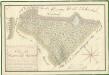
Geometrický plán lesa Kratoš a přilehlých činžovních pozemků 1

Mapy činžovních pozemků I. sekce třeboňského velkostatku pro obce: Borkovice, Bošilec, Drahotěšice, Frahelž, Hamr, Horusice, Lhota, Líšnice, Mažice, Mezimostí, Ponědraž, Ponědrážka, Řípec, Val, Vlkov 1
1 : 2880
Generální mapa panství Třeboň a inkorporovaných statků Bzí, Lomnice, Borovany, Třeboň, Hamr a Val 1

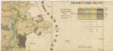
Přehledná mapa polesí Borkovice 1
Administrativní mapa třeboňského panství se statky Bzí,Lomnice, Borovany,Hamr a Val 1
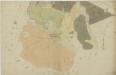
Borkovice o. Tábor 1
1 : 2880
Drachau - c1508-1-003 - Kaiserpflichtexemplar der Landkarten des stabilen Katasters
1 : 2880
Drachau - c1508-1-004 - Kaiserpflichtexemplar der Landkarten des stabilen Katasters
1 : 2880
Drachau - c1508-1-002 - Kaiserpflichtexemplar der Landkarten des stabilen Katasters
1 : 2880
Drachau - c1508-1-005 - Kaiserpflichtexemplar der Landkarten des stabilen Katasters
1 : 2880
Drachau - c1508-1-001 - Kaiserpflichtexemplar der Landkarten des stabilen Katasters
1 : 2880
Drachau - c1508-1-006 - Kaiserpflichtexemplar der Landkarten des stabilen Katasters
1 : 2880
Wessely - c8515-1-003 - Kaiserpflichtexemplar der Landkarten des stabilen Katasters
1 : 2880
Wessely - c8515-1-004 - Kaiserpflichtexemplar der Landkarten des stabilen Katasters
1 : 2880
Wessely - c8515-1-002 - Kaiserpflichtexemplar der Landkarten des stabilen Katasters
1 : 2880
Wessely - c8515-1-001 - Kaiserpflichtexemplar der Landkarten des stabilen Katasters
1 : 2880
Borkowitz - c0380-1-005 - Kaiserpflichtexemplar der Landkarten des stabilen Katasters
1 : 2880
Borkowitz - c0380-1-003 - Kaiserpflichtexemplar der Landkarten des stabilen Katasters
1 : 2880
Borkowitz - c0380-1-008 - Kaiserpflichtexemplar der Landkarten des stabilen Katasters
1 : 2880
Borkowitz - c0380-1-007 - Kaiserpflichtexemplar der Landkarten des stabilen Katasters
1 : 2880
Borkowitz - c0380-1-006 - Kaiserpflichtexemplar der Landkarten des stabilen Katasters
1 : 2880
Borkowitz - c0380-1-004 - Kaiserpflichtexemplar der Landkarten des stabilen Katasters
1 : 2880
Borkowitz - c0380-1-002 - Kaiserpflichtexemplar der Landkarten des stabilen Katasters
1 : 2880