Maps of Zvíkovské Podhradí

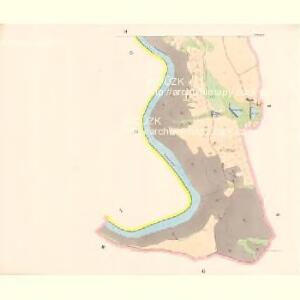
Podhrad - c9312-1-002 - Kaiserpflichtexemplar der Landkarten des stabilen Katasters
1 : 2880
Podhrad - c9312-1-001 - Kaiserpflichtexemplar der Landkarten des stabilen Katasters
1 : 2880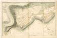
Geometrický nárys planiny jižně od hradu Zvíkova s vyznačením panského a selského majetku a parcel 1

Zvíkovské Podhradí (Podhrad), okr. Písek, list 2 list 2
1 : 2880
Stereofotogrammetrické zaměření... Vltavy, Otavy... pomocí Zeissova fototeodolitu

Stereofotogrammetrické zaměření... Vltavy, Otavy... pomocí Zeissova fototeodolitu
Stereofotogrammetrické zaměření... Vltavy, Otavy... pomocí Zeissova fototeodolitu
Situační násčrt navrženého přesídlení poddaných z Podhradu pod Zvíkovem do nově založené vsi Karlova 1

Lesní zařizovací mapa I. hlavního dílu revíru Spolle, zv. Komora 1

Jickovice s Vartou, okr. Písek, list 6 1
Oslov se sv. Annou a částí Červené, okr. Písek, list 13 1

Stereofotogrammetrické zaměření... Vltavy, Otavy... pomocí Zeissova fototeodolitu

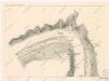
Náčrty trigomometrické sítě velkostatku Orlíka, dochovány pro obce Nevězice - Varvažov, okolí Orlíka, Květov, Slavoňov, Jetětice, Těchnice, Lety, Vrábsko, Tukleky, Zvíkov, Bukovany, Zlákovice, Hrazany, Mýšlovice, list 9 1

Woslow - c5540-1-009 - Kaiserpflichtexemplar der Landkarten des stabilen Katasters
1 : 2880
Woslow - c5540-1-005 - Kaiserpflichtexemplar der Landkarten des stabilen Katasters
1 : 2880
Woslow - c5540-1-006 - Kaiserpflichtexemplar der Landkarten des stabilen Katasters
1 : 2880
Woslow - c5540-1-003 - Kaiserpflichtexemplar der Landkarten des stabilen Katasters
1 : 2880
Woslow - c5540-1-007 - Kaiserpflichtexemplar der Landkarten des stabilen Katasters
1 : 2880
Woslow - c5540-1-002 - Kaiserpflichtexemplar der Landkarten des stabilen Katasters
1 : 2880
Woslow - c5540-1-004 - Kaiserpflichtexemplar der Landkarten des stabilen Katasters
1 : 2880
Woslow - c5540-1-008 - Kaiserpflichtexemplar der Landkarten des stabilen Katasters
1 : 2880
Woslow - c5540-1-001 - Kaiserpflichtexemplar der Landkarten des stabilen Katasters
1 : 2880
Zbonin - c9180-1-007 - Kaiserpflichtexemplar der Landkarten des stabilen Katasters
1 : 2880
Zbonin - c9180-1-005 - Kaiserpflichtexemplar der Landkarten des stabilen Katasters
1 : 2880
Zbonin - c9180-1-002 - Kaiserpflichtexemplar der Landkarten des stabilen Katasters
1 : 2880
Zbonin - c9180-1-006 - Kaiserpflichtexemplar der Landkarten des stabilen Katasters
1 : 2880
Zbonin - c9180-1-003 - Kaiserpflichtexemplar der Landkarten des stabilen Katasters
1 : 2880
Zbonin - c9180-1-004 - Kaiserpflichtexemplar der Landkarten des stabilen Katasters
1 : 2880
Zbonin - c9180-1-008 - Kaiserpflichtexemplar der Landkarten des stabilen Katasters
1 : 2880