Maps of Záblatí

Wierzenitz - c9304-1-002 - Kaiserpflichtexemplar der Landkarten des stabilen Katasters
1 : 2880
Wierzenitz - c9304-1-005 - Kaiserpflichtexemplar der Landkarten des stabilen Katasters
1 : 2880
Wierzenitz - c9304-1-001 - Kaiserpflichtexemplar der Landkarten des stabilen Katasters
1 : 2880
Wierzenitz - c9304-1-003 - Kaiserpflichtexemplar der Landkarten des stabilen Katasters
1 : 2880
Wierzenitz - c9304-1-004 - Kaiserpflichtexemplar der Landkarten des stabilen Katasters
1 : 2880
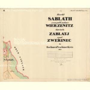
Sablath (Zablatj) - c9003-1-003 - Kaiserpflichtexemplar der Landkarten des stabilen Katasters
1 : 2880
Sablath (Zablatj) - c9003-1-001 - Kaiserpflichtexemplar der Landkarten des stabilen Katasters
1 : 2880
Sablath (Zablatj) - c9003-1-002 - Kaiserpflichtexemplar der Landkarten des stabilen Katasters
1 : 2880
Wihoržen - c1853-1-004 - Kaiserpflichtexemplar der Landkarten des stabilen Katasters
1 : 2880
Wihoržen - c1853-1-003 - Kaiserpflichtexemplar der Landkarten des stabilen Katasters
1 : 2880
Wihoržen - c1853-1-001 - Kaiserpflichtexemplar der Landkarten des stabilen Katasters
1 : 2880
Wihoržen - c1853-1-006 - Kaiserpflichtexemplar der Landkarten des stabilen Katasters
1 : 2880
Wihoržen - c1853-1-005 - Kaiserpflichtexemplar der Landkarten des stabilen Katasters
1 : 2880
Wihoržen - c1853-1-002 - Kaiserpflichtexemplar der Landkarten des stabilen Katasters
1 : 2880
Althütter Revier
1 : 27800 Prachatice-oblast (Česko) Schröter, Hugo Krejčí, Jan Verlag des böhm. Forstvereins
Mapka okolí Husince
Tschechische Republik Böhmen Husinec Hus, Jan
[Mapový list]
1 : 25000 Volary-oblast (Česko) Vojenský zeměpisný ústav
III. vojenské mapování 4452/1
1 : 25000

Schulwandkarte des politischen Bezirkes Krumau Blatt 1

Schulwandkarte des politischen Bezirkes Krumau Blatt 1

Podrobné mapy zemí Koruny české v měřítku 1:75.000 a mapa vzdáleností všech míst při silnici ležících. Volary - Kunžvart. Průvodce statisticko-historický po všech místech na těchto mapách uvedených a rejstřík věcný názvů hor, potoků, řek, rybníků atd. Sešit 31. List 35
1 : 75000
Podrobné mapy zemí Koruny české v měřítku 1:75.000 a mapa vzdáleností všech míst při silnici ležících
1 : 75000 Volary (Česko : oblast) Bělohlav, Josef F. Topič
Prachatice a okolí
1 : 75000 Prachatice (Česko : oblast) Vojenský zeměpisný ústav
Übersichtskarte der Herrschaft Winterberg
1 : 94800 Vimperk-oblast (Česko) Verlag des böhm. Forstverein's
III. vojenské mapování 4452
1 : 75000
Český Krumlov
1 : 75000 Čechy (Česko) Vojenský zeměpisný ústav
Český Krumlov
1 : 75000 Čechy (Česko) Vojenský zeměpisný ústav
Protiwin und Prachatitz
1 : 75000 Prachatice (Česko : oblast) K. u. k. Militärgeographisches Institut
Krumau und Wallern
1 : 75000 Volary (Česko : oblast) Kohout, F. K. u. k. militär geographisches Institut