Maps of Zaječov

Zageczow - c9093-1-003 - Kaiserpflichtexemplar der Landkarten des stabilen Katasters
1 : 2880
Zageczow - c9093-1-002 - Kaiserpflichtexemplar der Landkarten des stabilen Katasters
1 : 2880
Zageczow - c9093-1-001 - Kaiserpflichtexemplar der Landkarten des stabilen Katasters
1 : 2880
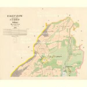
Kwain - c3737-1-009 - Kaiserpflichtexemplar der Landkarten des stabilen Katasters
1 : 2880
Kwain - c3737-1-008 - Kaiserpflichtexemplar der Landkarten des stabilen Katasters
1 : 2880
Kwain - c3737-1-005 - Kaiserpflichtexemplar der Landkarten des stabilen Katasters
1 : 2880
Kwain - c3737-1-006 - Kaiserpflichtexemplar der Landkarten des stabilen Katasters
1 : 2880
Kwain - c3737-1-004 - Kaiserpflichtexemplar der Landkarten des stabilen Katasters
1 : 2880
Kwain - c3737-1-001 - Kaiserpflichtexemplar der Landkarten des stabilen Katasters
1 : 2880
Kwain - c3737-1-003 - Kaiserpflichtexemplar der Landkarten des stabilen Katasters
1 : 2880
Kwain - c3737-1-002 - Kaiserpflichtexemplar der Landkarten des stabilen Katasters
1 : 2880
Kwain - c3737-1-010 - Kaiserpflichtexemplar der Landkarten des stabilen Katasters
1 : 2880
Kwain - c3737-1-007 - Kaiserpflichtexemplar der Landkarten des stabilen Katasters
1 : 2880
Wolleschna (Wollessna) - c5443-1-002 - Kaiserpflichtexemplar der Landkarten des stabilen Katasters
1 : 2880
Wolleschna (Wollessna) - c5443-1-003 - Kaiserpflichtexemplar der Landkarten des stabilen Katasters
1 : 2880
Wolleschna (Wollessna) - c5443-1-004 - Kaiserpflichtexemplar der Landkarten des stabilen Katasters
1 : 2880
Wolleschna (Wollessna) - c5443-1-001 - Kaiserpflichtexemplar der Landkarten des stabilen Katasters
1 : 2880
Wolleschna (Wollessna) - c5443-1-005 - Kaiserpflichtexemplar der Landkarten des stabilen Katasters
1 : 2880
Wolleschna (Wollessna) - c5443-1-006 - Kaiserpflichtexemplar der Landkarten des stabilen Katasters
1 : 2880
Jwynna - c2944-1-002 - Kaiserpflichtexemplar der Landkarten des stabilen Katasters
1 : 2880
Jwynna - c2944-1-003 - Kaiserpflichtexemplar der Landkarten des stabilen Katasters
1 : 2880
Jwynna - c2944-1-001 - Kaiserpflichtexemplar der Landkarten des stabilen Katasters
1 : 2880


Karte des Zbirower Bezirkes im Prager Kreise
1 : 72300 Zbiroh-oblast (Česko) Wagner, Jan Eduard Karl André
Generalkarte der kaiserl. königl. Reichsdomaine Zbirov
Zbiroh-oblast (Česko) Ponetz, Carl
Karte des Horowitzer Bezirkes im Prager Kreise
1 : 7300 Hořovice-oblast (Česko) Wagner, Jan Eduard Karl André
Karte des Horowitzer Bezirkes im Prager Kreise
1 : 7300 Hořovice-oblast (Česko) Wagner, Jan Eduard Karl André
Mapa školního a politického okresu Rokycanského
1 : 75000 Rokycany-oblast (Česko) Voj. zeměpisný ústav
Beraun und Hořowitz
1 : 75000 Beroun (Česko : oblast) Radler K. u. k. militär-geographisches Institut
Beraun und Hořowitz
1 : 75000 Beroun (Česko : oblast) Radler K. u. k. Militärgeographisches Institut