Maps of Zahořany

Zahorzan - c9051-1-003 - Kaiserpflichtexemplar der Landkarten des stabilen Katasters
1 : 2880
Zahorzan - c9051-1-004 - Kaiserpflichtexemplar der Landkarten des stabilen Katasters
1 : 2880
Zahorzan - c9051-1-001 - Kaiserpflichtexemplar der Landkarten des stabilen Katasters
1 : 2880
Zahorzan - c9051-1-002 - Kaiserpflichtexemplar der Landkarten des stabilen Katasters
1 : 2880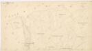
Katastrální mapa obce Zahořany
1 : 2880
Katastrální mapa obce Zahořany
1 : 2880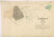
Katastrální mapa obce Zahořany
1 : 2880
Hospodářská mapa revíru Stanětice
1 : 6084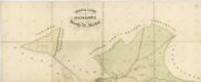
Mapa pozemků dvorů Kout, Starý dvůr a Nový Dvůr
1 : 2941
Sedlitz (Sedlice) - c6795-1-001 - Kaiserpflichtexemplar der Landkarten des stabilen Katasters
1 : 2880
Mapa pozemků Nového a Starého Dvora
1 : 5760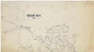
Honební mapa panství velkostatku Kout-Trhanov
1 : 25000
Hospodářská mapa revíru Stanětice
1 : 5835
Mapa pozemků dvorů Kout a Starý Dvůr
1 : 5760
Situační plán Nového a Starého Dvora
1 : 11520
Situační plán dvorů Kout, Starý a Nový Dvůr
1 : 7480
Přehledná mapa luk panství Kout
1 : 11257
Radonitz (Radonic) - c6373-1-003 - Kaiserpflichtexemplar der Landkarten des stabilen Katasters
1 : 2880
Radonitz (Radonic) - c6373-1-001 - Kaiserpflichtexemplar der Landkarten des stabilen Katasters
1 : 2880
Radonitz (Radonic) - c6373-1-002 - Kaiserpflichtexemplar der Landkarten des stabilen Katasters
1 : 2880
Stannetitz (Stanietice) - c7221-1-001 - Kaiserpflichtexemplar der Landkarten des stabilen Katasters
1 : 2880
Stannetitz (Stanietice) - c7221-1-002 - Kaiserpflichtexemplar der Landkarten des stabilen Katasters
1 : 2880
Stannetitz (Stanietice) - c7221-1-003 - Kaiserpflichtexemplar der Landkarten des stabilen Katasters
1 : 2880
Spaniow (Spaniowo) - c7171-1-003 - Kaiserpflichtexemplar der Landkarten des stabilen Katasters
1 : 2880
Spaniow (Spaniowo) - c7171-1-002 - Kaiserpflichtexemplar der Landkarten des stabilen Katasters
1 : 2880
Spaniow (Spaniowo) - c7171-1-001 - Kaiserpflichtexemplar der Landkarten des stabilen Katasters
1 : 2880
Opprechtitz (Opprechticz) - c5505-1-002 - Kaiserpflichtexemplar der Landkarten des stabilen Katasters
1 : 2880
Opprechtitz (Opprechticz) - c5505-1-001 - Kaiserpflichtexemplar der Landkarten des stabilen Katasters
1 : 2880
Opprechtitz (Opprechticz) - c5505-1-003 - Kaiserpflichtexemplar der Landkarten des stabilen Katasters
1 : 2880


