Maps of Trnov

Zadol - c9034-1-001 - Kaiserpflichtexemplar der Landkarten des stabilen Katasters
1 : 2880
Zadol - c9034-1-002 - Kaiserpflichtexemplar der Landkarten des stabilen Katasters
1 : 2880
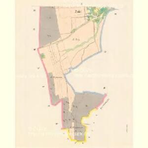
Trnow - c7974-1-003 - Kaiserpflichtexemplar der Landkarten des stabilen Katasters
1 : 2880
Trnow - c7974-1-004 - Kaiserpflichtexemplar der Landkarten des stabilen Katasters
1 : 2880
Trnow - c7974-1-001 - Kaiserpflichtexemplar der Landkarten des stabilen Katasters
1 : 2880
Trnow - c7974-1-002 - Kaiserpflichtexemplar der Landkarten des stabilen Katasters
1 : 2880
Zahornitz (Zahornice) - c9048-1-002 - Kaiserpflichtexemplar der Landkarten des stabilen Katasters
1 : 2880
Zahornitz (Zahornice) - c9048-1-001 - Kaiserpflichtexemplar der Landkarten des stabilen Katasters
1 : 2880
Haudkowitz (Haudkowice) - c2274-1-003 - Kaiserpflichtexemplar der Landkarten des stabilen Katasters
1 : 2880
Haudkowitz (Haudkowice) - c2274-1-001 - Kaiserpflichtexemplar der Landkarten des stabilen Katasters
1 : 2880
Haudkowitz (Haudkowice) - c2274-1-002 - Kaiserpflichtexemplar der Landkarten des stabilen Katasters
1 : 2880
III. vojenské mapování 3956/2
1 : 25000
Mapa dřevin revírů Kunštátského, Černovodského, Říčeckého a Zdobnického, patřících svěřenskému statku Rychnovu
Rychnov nad Kněžnou-oblast (Česko) Barth, Antoš Meinhard, Carl

Okres Rychnov nad Kněžnou

Mapa okresního hejtmanství Rychnovského
1 : 100000 Rychnov nad Kněžnou-oblast (Česko) Erben, Josef nákladem Karla Janského
Josefov a okolí
1 : 75000 Jaroměř (Česko : oblast) Vojenský zeměpisný ústav
Mapa okresního hejtmanství Rychnovského

Mapa okresního hejtmanství Rychnovského

Mapa okresního hejtmanství Novoměstského n/M
1 : 100000 Nové Město nad Metují-oblast (Česko) Erben, Josef nákladem Karla Janského
Politický okres novoměstský
Nové Město nad Metují-oblast (Česko) Srp, Jan Luther, Th. Jos. R. Vilímek
Camp que l'armée de Sa Majesté l'imperatrice sous les ordres du prince Picolomini á occupe pour observer la retraite de l'armée prussienne sous le comandement du comte Swerin
1 : 110000 Hradec Králové-oblast (Česko)
Karte des Schulbezirkes Senftenberg
1 : 150000 Žamberk-oblast (Česko) Weiner, J.
Generální mapa okresního hejtmanství Nov. Města nad Metují
1 : 220000 Nové Město nad Metují-oblast (Česko) Wagner, Jan Eduard F. Kytka
Generální mapa okresního hejtmanství Nov. Města nad Metují
1 : 220000 Nové Město nad Metují-oblast (Česko) Wagner, Jan Eduard F. Kytka
Das Adlergebirge
Orlické hory (Česko a Polsko) Deutscher Gebirgsverein für das Adlergebirge
Josefstadt und Nachod.
from Spezialkarte der osterreichisch-ungarischen Monarchie.
Plan der Attaqen so während den bishering Stellungen der kayser. könig. u. könig. preuss. Arméen in der Gegend von Jaromirz Nachod Arnau und Hohen Elb in Böhmen vorgefallen 1778
1 : 100000 Hostinné-oblast (Česko) Will, Johann Martin Joh. Mart. Will
Reichenau und Tinischt a.d. Adler.
from Spezialkarte der osterreichisch-ungarischen Monarchie.