Maps of Všenice

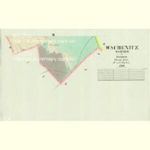
Wschenitz (Wssenice) - c8897-1-002 - Kaiserpflichtexemplar der Landkarten des stabilen Katasters
1 : 2880
Wschenitz (Wssenice) - c8897-1-001 - Kaiserpflichtexemplar der Landkarten des stabilen Katasters
1 : 2880
Strzapoll (Střapole) - c7441-1-002 - Kaiserpflichtexemplar der Landkarten des stabilen Katasters
1 : 2880
Strzapoll (Střapole) - c7441-1-003 - Kaiserpflichtexemplar der Landkarten des stabilen Katasters
1 : 2880
Strzapoll (Střapole) - c7441-1-001 - Kaiserpflichtexemplar der Landkarten des stabilen Katasters
1 : 2880
Ober Stupno (Horzegssy Stupno) - c7520-1-002 - Kaiserpflichtexemplar der Landkarten des stabilen Katasters
1 : 2880
Ober Stupno (Horzegssy Stupno) - c7520-1-003 - Kaiserpflichtexemplar der Landkarten des stabilen Katasters
1 : 2880
Ober Stupno (Horzegssy Stupno) - c7520-1-001 - Kaiserpflichtexemplar der Landkarten des stabilen Katasters
1 : 2880
Krzisch (Křzisse) - c0546-2-001 - Kaiserpflichtexemplar der Landkarten des stabilen Katasters
1 : 2880
Krzisch (Křzisse) - c0546-2-002 - Kaiserpflichtexemplar der Landkarten des stabilen Katasters
1 : 2880
Krzisch (Křzisse) - c0546-2-004 - Kaiserpflichtexemplar der Landkarten des stabilen Katasters
1 : 2880
Krzisch (Křzisse) - c0546-2-003 - Kaiserpflichtexemplar der Landkarten des stabilen Katasters
1 : 2880
III. vojenské mapování 3652/3
1 : 25000
[Kartenblatt]
1 : 25000 Břasy (Česko : oblast) Reichsamt für Landesaufnahme
III. vojenské mapování 4051/3
1 : 25000
Gradkartenblatt
1 : 25000 Třemošná-oblast (Česko) Bulla, Eduard
III. vojenské mapování 4051/3
1 : 25000

Podrobné mapy zemí Koruny české v měřítku 1:75.000 a mapa vzdáleností všech míst při silnici ležících.. Průvodce statisticko-historický po všech místech na těchto mapách uvedených a rejstřík věcný názvů hor, potoků, řek, rybníků atd. Sešit 28. List 30,
1 : 75000
Regni Bohemiae Circulus Pilsnensis
1 : 220000 Plzeň-oblast (Česko) Müller, Johann Christoph ab Homannianis Heredibus
Regni Bohemiae Circulus Pilsnensis
1 : 220000 Plzeň-oblast (Česko) Müller, Johann Christoph ab Homannianis Heredibus
Regni Bohemiae Circulus Pilsnensis
1 : 200000 Plzeň-oblast (Česko) Müller, Johann Christoph ab Homannianis Heredibus
Regni Bohemiae Circulus Pilsnensis
1 : 220000 Plzeň-oblast (Česko) Müller, Johann Christoph ab Homannianis Heredibus
Kralovice
1 : 75000 Kralovice (Plzeň-sever, Česko : oblast) Vojenský zeměpisný ústav
Pilsen und dessen Umgebung přehledka

Plzeň a okolí
1 : 75000 Plzeň (Česko : oblast) Vojenský zeměpisný ústav
Kralowitz und Břas
1 : 75000 Břasy (Česko : oblast) Schulenburg, J. K. u. k. Militärgeographisches Institut
Kralowitz und Břas
1 : 75000 Břasy-oblast (Česko) K. u. k. Militärgeographisches Institut
Mapa školního a politického okresu Rokycanského
1 : 75000 Rokycany-oblast (Česko) Voj. zeměpisný ústav
Kralovice
1 : 75000 Kralovice-oblast (Plzeň-sever, Česko) Vojenský zeměpisný ústav