Maps of Kočov

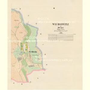
Wiedowitz - c8639-1-002 - Kaiserpflichtexemplar der Landkarten des stabilen Katasters
1 : 2880
Wiedowitz - c8639-1-001 - Kaiserpflichtexemplar der Landkarten des stabilen Katasters
1 : 2880
Hospodářská mapa revíru Kočov
1 : 4350
Katastrální mapa obce Damnov ZS-XIII-20 de
1 : 2880
Katastrální mapa obce Pavlovice
1 : 2880
Truss - c8271-1-001 - Kaiserpflichtexemplar der Landkarten des stabilen Katasters
1 : 2880
Hospodářská mapa revíru Kočov
1 : 11520
Pawlowitz (Pawlowice) - c5668-1-002 - Kaiserpflichtexemplar der Landkarten des stabilen Katasters
1 : 2880
Pawlowitz (Pawlowice) - c5668-1-003 - Kaiserpflichtexemplar der Landkarten des stabilen Katasters
1 : 2880
Pawlowitz (Pawlowice) - c5668-1-001 - Kaiserpflichtexemplar der Landkarten des stabilen Katasters
1 : 2880
Pawlowitz (Pawlowice) - c5668-1-004 - Kaiserpflichtexemplar der Landkarten des stabilen Katasters
1 : 2880
Gottschau - c3243-1-003 - Kaiserpflichtexemplar der Landkarten des stabilen Katasters
1 : 2880
Gottschau - c3243-1-001 - Kaiserpflichtexemplar der Landkarten des stabilen Katasters
1 : 2880
Gottschau - c3243-1-004 - Kaiserpflichtexemplar der Landkarten des stabilen Katasters
1 : 2880
Gottschau - c3243-1-002 - Kaiserpflichtexemplar der Landkarten des stabilen Katasters
1 : 2880
Gottschau - c3243-1-005 - Kaiserpflichtexemplar der Landkarten des stabilen Katasters
1 : 2880
Gottschau - c3243-1-006 - Kaiserpflichtexemplar der Landkarten des stabilen Katasters
1 : 2880
Katastrální mapa obce Pavlovice ZSL-XIII-19 de
1 : 2880
Wesigau - c0153-1-002 - Kaiserpflichtexemplar der Landkarten des stabilen Katasters
1 : 2880
Wesigau - c0153-1-003 - Kaiserpflichtexemplar der Landkarten des stabilen Katasters
1 : 2880
Wesigau - c0153-1-001 - Kaiserpflichtexemplar der Landkarten des stabilen Katasters
1 : 2880
Katastrální mapa obce Pavlovice ZSL-XIII-19 di
1 : 2880
Katastrální mapa obce Pavlovice
1 : 2880
Porostní mapa revíru Pavlovice
1 : 5760
Hospodářská mapa revíru Pavlovice
1 : 2880
Hospodářská mapa revíru Pavlovice
1 : 2689
Katastrální mapa obce Pavlovice
1 : 2880
Záměrná mapa revíru Kočov
1 : 2963
Katastrální mapa obce Pavlovice
1 : 2880