Maps of Chotěnov

Setsch (Secz) - c8567-1-004 - Kaiserpflichtexemplar der Landkarten des stabilen Katasters
1 : 2880
Setsch (Secz) - c8567-1-002 - Kaiserpflichtexemplar der Landkarten des stabilen Katasters
1 : 2880
Setsch (Secz) - c8567-1-001 - Kaiserpflichtexemplar der Landkarten des stabilen Katasters
1 : 2880
Setsch (Secz) - c8567-1-003 - Kaiserpflichtexemplar der Landkarten des stabilen Katasters
1 : 2880
Indikační skica mapy stabilního katastru pro obec Vidlatá Seč I; VI
1 : 2880
Indikační skica mapy stabilního katastru pro obec Vidlatá Seč III
1 : 2880
Indikační skica mapy stabilního katastru pro obec Vidlatá Seč V
1 : 2880
Indikační skica mapy stabilního katastru pro obec Chotěnov I
1 : 2880
Indikační skica mapy stabilního katastru pro obec Vidlatá Seč I
1 : 2880
Porostní mapa farního lesa v Dolním Újezdě
1 : 5760
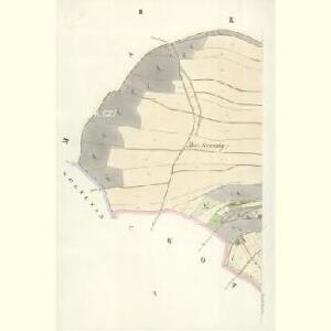
Chotienow - c2584-1-002 - Kaiserpflichtexemplar der Landkarten des stabilen Katasters
1 : 2880
Chotienow - c2584-1-001 - Kaiserpflichtexemplar der Landkarten des stabilen Katasters
1 : 2880
Indikační skica mapy stabilního katastru pro obec Dolní Újezd a osady Jiříkov a Václavky II; XII
1 : 2880
Indikační skica mapy stabilního katastru pro obec Morašice a osady Nová Sídla a Malé Sedliště (Sedlíšťka) VII; VIII
1 : 2880
Wolschan (Wolssan) - c5459-1-001 - Kaiserpflichtexemplar der Landkarten des stabilen Katasters
1 : 2880
Wolschan (Wolssan) - c5459-1-002 - Kaiserpflichtexemplar der Landkarten des stabilen Katasters
1 : 2880
Indikační skica mapy stabilního katastru pro obec Dolní Újezd a osady Jiříkov a Václavky IV
1 : 2880
Katastrální mapa obce Horní Újezd I; V
1 : 2880
Makau (Makow) - c4358-1-001 - Kaiserpflichtexemplar der Landkarten des stabilen Katasters
1 : 2880
Makau (Makow) - c4358-1-003 - Kaiserpflichtexemplar der Landkarten des stabilen Katasters
1 : 2880
Makau (Makow) - c4358-1-002 - Kaiserpflichtexemplar der Landkarten des stabilen Katasters
1 : 2880
Makau (Makow) - c4358-1-004 - Kaiserpflichtexemplar der Landkarten des stabilen Katasters
1 : 2880
Dessna (Desna) - c1087-1-002 - Kaiserpflichtexemplar der Landkarten des stabilen Katasters
1 : 2880
Dessna (Desna) - c1087-1-001 - Kaiserpflichtexemplar der Landkarten des stabilen Katasters
1 : 2880
Dessna (Desna) - c1087-1-003 - Kaiserpflichtexemplar der Landkarten des stabilen Katasters
1 : 2880
Indikační skica mapy stabilního katastru pro obec Lažany V
1 : 2880
Laschan (Lažan) - c3825-1-002 - Kaiserpflichtexemplar der Landkarten des stabilen Katasters
1 : 2880
Laschan (Lažan) - c3825-1-001 - Kaiserpflichtexemplar der Landkarten des stabilen Katasters
1 : 2880
Laschan (Lažan) - c3825-1-003 - Kaiserpflichtexemplar der Landkarten des stabilen Katasters
1 : 2880