Maps of Dolní Olešnice

Neustadtl (Westřew) - c8535-1-002 - Kaiserpflichtexemplar der Landkarten des stabilen Katasters
1 : 2880
Neustadtl (Westřew) - c8535-1-001 - Kaiserpflichtexemplar der Landkarten des stabilen Katasters
1 : 2880
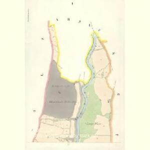
Nieder-Öls (Dolegnj Wolessnice) - c1354-1-005 - Kaiserpflichtexemplar der Landkarten des stabilen Katasters
1 : 2880
Nieder-Öls (Dolegnj Wolessnice) - c1354-1-002 - Kaiserpflichtexemplar der Landkarten des stabilen Katasters
1 : 2880
Nieder-Öls (Dolegnj Wolessnice) - c1354-1-007 - Kaiserpflichtexemplar der Landkarten des stabilen Katasters
1 : 2880
Nieder-Öls (Dolegnj Wolessnice) - c1354-1-001 - Kaiserpflichtexemplar der Landkarten des stabilen Katasters
1 : 2880
Nieder-Öls (Dolegnj Wolessnice) - c1354-1-003 - Kaiserpflichtexemplar der Landkarten des stabilen Katasters
1 : 2880
Nieder-Öls (Dolegnj Wolessnice) - c1354-1-006 - Kaiserpflichtexemplar der Landkarten des stabilen Katasters
1 : 2880
Nieder-Öls (Dolegnj Wolessnice) - c1354-1-004 - Kaiserpflichtexemplar der Landkarten des stabilen Katasters
1 : 2880
Kottwitz (Kottwice) - c2594-1-001 - Kaiserpflichtexemplar der Landkarten des stabilen Katasters
1 : 2880
Kottwitz (Kottwice) - c2594-1-005 - Kaiserpflichtexemplar der Landkarten des stabilen Katasters
1 : 2880
Kottwitz (Kottwice) - c2594-1-004 - Kaiserpflichtexemplar der Landkarten des stabilen Katasters
1 : 2880
Kottwitz (Kottwice) - c2594-1-003 - Kaiserpflichtexemplar der Landkarten des stabilen Katasters
1 : 2880
Kottwitz (Kottwice) - c2594-1-002 - Kaiserpflichtexemplar der Landkarten des stabilen Katasters
1 : 2880
Arnau (Hostina) - c2248-1-002 - Kaiserpflichtexemplar der Landkarten des stabilen Katasters
1 : 2880
Arnau (Hostina) - c2248-1-003 - Kaiserpflichtexemplar der Landkarten des stabilen Katasters
1 : 2880
Arnau (Hostina) - c2248-1-001 - Kaiserpflichtexemplar der Landkarten des stabilen Katasters
1 : 2880
Arnau (Hostina) - c2248-1-004 - Kaiserpflichtexemplar der Landkarten des stabilen Katasters
1 : 2880
[Kartenblatt]
1 : 25000 Hostinné (Česko : oblast) Reichsamt für Landesaufnahme
[Gradkartenblatt]
1 : 25000 Hostinné-oblast (Česko) Vojenský zeměpisný ústav
Vertretungsbezirk Arnau


Topographische und Militairische Carte desienigen Theils von Boehmen...

Karte des politischen Bezirkes Königinhof

Hohenelbe
1 : 75000 Vrchlabí (Česko : oblast) K. u. k. Militärgeographisches Institut
III. vojenské mapování 3755
1 : 75000
Trutnov a okolí