Maps of Kočov

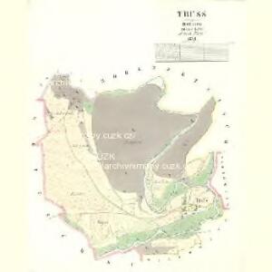
Truss - c8271-1-001 - Kaiserpflichtexemplar der Landkarten des stabilen Katasters
1 : 2880
Hospodářská mapa revíru Kočov
1 : 4377
Hospodářská mapa revíru Kočov
1 : 4343
Katastrální mapa obce Pavlovice ZSL-XIV-19 ah, ai
1 : 2880
Katastrální mapa obce Pavlovice
1 : 2880
Gottschau - c3243-1-003 - Kaiserpflichtexemplar der Landkarten des stabilen Katasters
1 : 2880
Gottschau - c3243-1-001 - Kaiserpflichtexemplar der Landkarten des stabilen Katasters
1 : 2880
Gottschau - c3243-1-004 - Kaiserpflichtexemplar der Landkarten des stabilen Katasters
1 : 2880
Gottschau - c3243-1-002 - Kaiserpflichtexemplar der Landkarten des stabilen Katasters
1 : 2880
Gottschau - c3243-1-005 - Kaiserpflichtexemplar der Landkarten des stabilen Katasters
1 : 2880
Gottschau - c3243-1-006 - Kaiserpflichtexemplar der Landkarten des stabilen Katasters
1 : 2880
Porostní mapa revíru Vysoké Sedliště
1 : 5760
Hospodářská mapa revíru Kočov
1 : 4343
Hospodářská mapa revíru Kočov
1 : 4350
Hohenzetlisch - c8961-1-002 - Kaiserpflichtexemplar der Landkarten des stabilen Katasters
1 : 2880
Hohenzetlisch - c8961-1-004 - Kaiserpflichtexemplar der Landkarten des stabilen Katasters
1 : 2880
Hohenzetlisch - c8961-1-001 - Kaiserpflichtexemplar der Landkarten des stabilen Katasters
1 : 2880
Hohenzetlisch - c8961-1-003 - Kaiserpflichtexemplar der Landkarten des stabilen Katasters
1 : 2880
Wiedowitz - c8639-1-002 - Kaiserpflichtexemplar der Landkarten des stabilen Katasters
1 : 2880
Wiedowitz - c8639-1-001 - Kaiserpflichtexemplar der Landkarten des stabilen Katasters
1 : 2880
Hospodářská mapa revíru Pavlovice
1 : 2880
Hospodářská mapa revíru Kočov
1 : 11520
[Kartenblatt]
1 : 25000 Planá (Tachov, Česko : oblast) Reichsamt für Landesaufnahme
III. vojenské mapování 4049/4
1 : 25000

Gradkartenblatt
1 : 25000 Tachov-oblast (Česko) Bulla, Eduard
Hospodářská mapa revíru Kočov
1 : 4350
Uibersichtskarte der Herrschaft Tachau
Tachov-oblast (Česko) Waraus, E. André Verlag des böhm. Forstvereins
Hayder Vicariat
Bor-oblast (Tachov, Česko)
Marienbad und Tachau
1 : 75000 Mariánské Lázně (Česko : oblast) Höller, K. K. u. k. Militärgeographisches Institut