Maps of Úhřetická Lhota

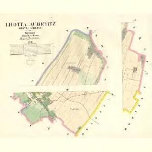
Lhotta Auřetitz (Lhotta Auřetic) - c8193-1-002 - Kaiserpflichtexemplar der Landkarten des stabilen Katasters
1 : 2880
Lhotta Auřetitz (Lhotta Auřetic) - c8193-1-001 - Kaiserpflichtexemplar der Landkarten des stabilen Katasters
1 : 2880
Indikační skica mapy stabilního katastru pro obec Úhřetická Lhota I.-III.
1 : 2880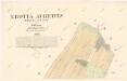
Indikační skica mapy stabilního katastru pro obec Úhřetická Lhota I.
1 : 2880
Indikační skica mapy stabilního katastru pro obec Úhřetická Lhota I., III., ad II.
1 : 2880
Hostowitz (Hostowice) - c2258-1-001 - Kaiserpflichtexemplar der Landkarten des stabilen Katasters
1 : 2880
Hostowitz (Hostowice) - c2258-1-002 - Kaiserpflichtexemplar der Landkarten des stabilen Katasters
1 : 2880
Hostowitz (Hostowice) - c2258-1-003 - Kaiserpflichtexemplar der Landkarten des stabilen Katasters
1 : 2880
Aurzetitz (Auřetice) - c8192-1-002 - Kaiserpflichtexemplar der Landkarten des stabilen Katasters
1 : 2880
Aurzetitz (Auřetice) - c8192-1-001 - Kaiserpflichtexemplar der Landkarten des stabilen Katasters
1 : 2880
Aurzetitz (Auřetice) - c8192-1-003 - Kaiserpflichtexemplar der Landkarten des stabilen Katasters
1 : 2880
Indikační skica mapy stabilního katastru pro obec Hostovice III.
1 : 2880
Katastrální mapa obce Tuněchody
1 : 2880
Indikační skica mapy stabilního katastru pro obec Hostovice I.-V.
1 : 2880
Indikační skica mapy stabilního katastru pro obec Kostěnice I.-IV.
1 : 2880
Dwakatschowitz (Dwakačowice) - c1617-1-002 - Kaiserpflichtexemplar der Landkarten des stabilen Katasters
1 : 2880
Dwakatschowitz (Dwakačowice) - c1617-1-001 - Kaiserpflichtexemplar der Landkarten des stabilen Katasters
1 : 2880
Koschtenitz (Kosstenice) - c3387-1-001 - Kaiserpflichtexemplar der Landkarten des stabilen Katasters
1 : 2880
Koschtenitz (Kosstenice) - c3387-1-004 - Kaiserpflichtexemplar der Landkarten des stabilen Katasters
1 : 2880
Koschtenitz (Kosstenice) - c3387-1-002 - Kaiserpflichtexemplar der Landkarten des stabilen Katasters
1 : 2880
Koschtenitz (Kosstenice) - c3387-1-003 - Kaiserpflichtexemplar der Landkarten des stabilen Katasters
1 : 2880
Indikační skica mapy stabilního katastru pro obec Kostěnice III.
1 : 2880
Indikační skica mapy stabilního katastru pro obec Hostovice IV.
1 : 2880
Mapa politického okresu Pardubického


Eisenbahn Karte Wien-Dresden, Ollmütz-Trübau
1 : 72000 Blatt 10 Minarzik, Anselm J. Rauh
8. Kraj Pardubický

Chrudim a okolí
1 : 75000 Chrudim (Česko : oblast) Vojenský zeměpisný ústav