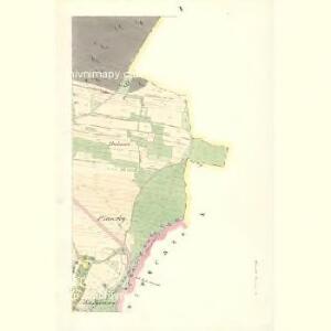
Maps of Týnišťko

Tinisko - c8158-1-001 - Kaiserpflichtexemplar der Landkarten des stabilen Katasters
1 : 2880
Tinisko - c8158-1-002 - Kaiserpflichtexemplar der Landkarten des stabilen Katasters
1 : 2880
Tinisko - c8158-1-003 - Kaiserpflichtexemplar der Landkarten des stabilen Katasters
1 : 2880
Tinisko - c8158-1-004 - Kaiserpflichtexemplar der Landkarten des stabilen Katasters
1 : 2880
Indikační skica mapy stabilního katastru pro obec Týníšťko IV
1 : 2880
Katastrální mapa pro obec Týníšťko
1 : 2880
Katastrální mapa pro obec Týníšťko
1 : 2880
Katastrální mapa pro obec Týníšťko
1 : 2880
Katastrální mapa pro obec Týníšťko
1 : 2880
Indikační skica mapy stabilního katastru pro obec Týníšťko VI
1 : 2880
Katastrální mapa pro obec Týníšťko
1 : 2880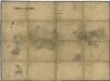
Porostní mapa polesí Uhersko
1 : 10000
Mapa polesí Uhersko - sever
1 : 10000
Mapa polesí Uhersko
1 : 10000
Rzy - c6674-1-002 - Kaiserpflichtexemplar der Landkarten des stabilen Katasters
1 : 2880
Rzy - c6674-1-003 - Kaiserpflichtexemplar der Landkarten des stabilen Katasters
1 : 2880
Rzy - c6674-1-001 - Kaiserpflichtexemplar der Landkarten des stabilen Katasters
1 : 2880
Jaroslaw - c2774-1-003 - Kaiserpflichtexemplar der Landkarten des stabilen Katasters
1 : 2880
Jaroslaw - c2774-1-002 - Kaiserpflichtexemplar der Landkarten des stabilen Katasters
1 : 2880
Jaroslaw - c2774-1-004 - Kaiserpflichtexemplar der Landkarten des stabilen Katasters
1 : 2880
Jaroslaw - c2774-1-001 - Kaiserpflichtexemplar der Landkarten des stabilen Katasters
1 : 2880
Mapa pozemků a drenáže vrchnostenského dvora v Radhošti
1 : 2880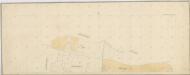
Katastrální mapa pro obec Radhošť
1 : 2880
Janowitschek - c2765-1-002 - Kaiserpflichtexemplar der Landkarten des stabilen Katasters
1 : 2880
Janowitschek - c2765-1-001 - Kaiserpflichtexemplar der Landkarten des stabilen Katasters
1 : 2880
Radhoscht (Radhosst) - c6342-1-002 - Kaiserpflichtexemplar der Landkarten des stabilen Katasters
1 : 2880
Radhoscht (Radhosst) - c6342-1-001 - Kaiserpflichtexemplar der Landkarten des stabilen Katasters
1 : 2880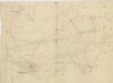
Indikační skica mapy stabilního katastru pro obec Radhošť
1 : 2880
Indikační skica mapy stabilního katastru pro obec Týníšťko
1 : 2880