Maps of Dubné

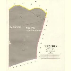
Trzebin - c8028-1-002 - Kaiserpflichtexemplar der Landkarten des stabilen Katasters
1 : 2880
Trzebin - c8028-1-001 - Kaiserpflichtexemplar der Landkarten des stabilen Katasters
1 : 2880
Dubné, berní okres České Budějovice, Čechy
1 : 2880 Dubné (Česko) Reprodukční ústav Ministerstva financí
Duben - c1598-1-003 - Kaiserpflichtexemplar der Landkarten des stabilen Katasters
1 : 2880
Duben - c1598-1-002 - Kaiserpflichtexemplar der Landkarten des stabilen Katasters
1 : 2880
Duben - c1598-1-004 - Kaiserpflichtexemplar der Landkarten des stabilen Katasters
1 : 2880
Duben - c1598-1-001 - Kaiserpflichtexemplar der Landkarten des stabilen Katasters
1 : 2880
Pranischen - c0462-1-004 - Kaiserpflichtexemplar der Landkarten des stabilen Katasters
1 : 2880
Pranischen - c0462-1-003 - Kaiserpflichtexemplar der Landkarten des stabilen Katasters
1 : 2880
Pranischen - c0462-1-001 - Kaiserpflichtexemplar der Landkarten des stabilen Katasters
1 : 2880
Pranischen - c0462-1-002 - Kaiserpflichtexemplar der Landkarten des stabilen Katasters
1 : 2880
Pranischen - c0462-1-005 - Kaiserpflichtexemplar der Landkarten des stabilen Katasters
1 : 2880
Gauendorf - c4818-1-001 - Kaiserpflichtexemplar der Landkarten des stabilen Katasters
1 : 2880
Gauendorf in Böhmen
1 : 2880 Mokré (Litvínovice, Česko) K.k. Lithografische Institut des Grundsteuerkatasters
České Budějovice se situačním plánkem letiště


[Mapový list]
1 : 25000 Čechy (Česko) Vojenský zeměpisný ústav
Gradkartenblatt
1 : 25000 Čechy (Česko) Gerstner, Eduard von
III. vojenské mapování 4453/1
1 : 25000
[České Budějovice a okolí]
České Budějovice-oblast (Česko)
Vltava jižně od Prahy

Umgebung von Budweis
1 : 37000 České Budějovice-oblast (Česko) Popper, Filipp L.E. Hansen
Topographische Karte ... Herrschaft Krummau ...

Topographische Karte der in Böhmen budweiser Kreises liegenden

Schulwandkarte des politischen Bezirkes Krumau Blatt 2

Podrobné mapy zemí Koruny české v měřítku 1:75.000 a mapa vzdáleností všech míst při silnici ležících - České Budějovice - Trhové Sviny. Průvodce statisticko-historický po všech místech na těchto mapách uvedených a rejstřík věcný názvů hor, potoků, řek, rybníků atd. Sešit 33. List 61,
1 : 75000
Podrobné mapy zemí Koruny české v měřítku 1:75.000 a mapy vzdáleností všech míst při silnici ležících
1 : 75000 Trhové Sviny (Česko : oblast) Bělohlav, Josef F. Topič
České Budějovice a okolí
1 : 75000 České Budějovice (Česko : oblast) Vojenský zeměpisný ústav
Budweis und Gratzen
1 : 75000 Nové Hrady (České Budějovice, Česko : oblast) Noltz, F. K. u. k. militär-geographisches Institut
Budweis und Gratzen
1 : 75000 Nové Hrady (České Budějovice, Česko : oblast) Noltz, F. K. u. k. militär-geographisches Institut