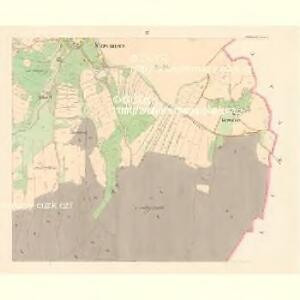
Maps of Vrhaveč

Stresmierz (Stresměrz) - c7460-1-003 - Kaiserpflichtexemplar der Landkarten des stabilen Katasters
1 : 2880
Stresmierz (Stresměrz) - c7460-1-001 - Kaiserpflichtexemplar der Landkarten des stabilen Katasters
1 : 2880
Stresmierz (Stresměrz) - c7460-1-002 - Kaiserpflichtexemplar der Landkarten des stabilen Katasters
1 : 2880
Hospodářská mapa revíru Obora
1 : 2918
Hospodářská mapa revíru Hubenov
1 : 2918
Katastrální mapa obce Střeziměř
1 : 2880
Katastrální mapa obce Střeziměř s osadou Dobrá Voda WC-VIII-26-27 ci cf
1 : 2880
Katastrální mapa obce Střeziměř s osadou Dobrá Voda WC-VIII-26-27 ci cf
1 : 2880
Katastrální mapa obce Chlístov
1 : 2880
Katastrální mapa obce Běšiny s osadou Hubenov
1 : 2880
Katastrální mapa obce Radinovy WC-IX-VIII-26-27 ai di af df
1 : 2880
Radinau (Radinow) - c6354-1-002 - Kaiserpflichtexemplar der Landkarten des stabilen Katasters
1 : 2880
Radinau (Radinow) - c6354-1-001 - Kaiserpflichtexemplar der Landkarten des stabilen Katasters
1 : 2880
Krischtin - c3652-1-001 - Kaiserpflichtexemplar der Landkarten des stabilen Katasters
1 : 2880
Krischtin - c3652-1-002 - Kaiserpflichtexemplar der Landkarten des stabilen Katasters
1 : 2880
Katastrální mapa obce Radinovy
1 : 2880
Katastrální mapa obce Radinovy
1 : 2880
Katastrální mapa obce Radinovy
1 : 2880
Katastrální mapa obce Křištín WC-VIII-26 di
1 : 2880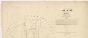
Katastrální mapa obce Chlístov
1 : 2880
Hospodářská mapa revíru Srbice
1 : 2880
Katastrální mapa obce Horní Lhota
1 : 2880
Bieschin (Běssiny) - c0213-1-003 - Kaiserpflichtexemplar der Landkarten des stabilen Katasters
1 : 2880
Bieschin (Běssiny) - c0213-1-002 - Kaiserpflichtexemplar der Landkarten des stabilen Katasters
1 : 2880
Bieschin (Běssiny) - c0213-1-004 - Kaiserpflichtexemplar der Landkarten des stabilen Katasters
1 : 2880
Bieschin (Běssiny) - c0213-1-005 - Kaiserpflichtexemplar der Landkarten des stabilen Katasters
1 : 2880
Bieschin (Běssiny) - c0213-1-001 - Kaiserpflichtexemplar der Landkarten des stabilen Katasters
1 : 2880
Porostní mapa revíru Běšiny
1 : 5000
Chlistau - c2489-1-002 - Kaiserpflichtexemplar der Landkarten des stabilen Katasters
1 : 2880
Chlistau - c2489-1-003 - Kaiserpflichtexemplar der Landkarten des stabilen Katasters
1 : 2880