Maps of Bolešiny

Slawoschowitz (Slawossowice) - c7034-1-002 - Kaiserpflichtexemplar der Landkarten des stabilen Katasters
1 : 2880
Slawoschowitz (Slawossowice) - c7034-1-001 - Kaiserpflichtexemplar der Landkarten des stabilen Katasters
1 : 2880
Bolleschin (Bollessiny) - c0346-1-003 - Kaiserpflichtexemplar der Landkarten des stabilen Katasters
1 : 2880
Bolleschin (Bollessiny) - c0346-1-004 - Kaiserpflichtexemplar der Landkarten des stabilen Katasters
1 : 2880
Bolleschin (Bollessiny) - c0346-1-001 - Kaiserpflichtexemplar der Landkarten des stabilen Katasters
1 : 2880
Bolleschin (Bollessiny) - c0346-1-002 - Kaiserpflichtexemplar der Landkarten des stabilen Katasters
1 : 2880
Kidlin (Kidlini) - c3761-1-003 - Kaiserpflichtexemplar der Landkarten des stabilen Katasters
1 : 2880
Kidlin (Kidlini) - c3761-1-001 - Kaiserpflichtexemplar der Landkarten des stabilen Katasters
1 : 2880
Kidlin (Kidlini) - c3761-1-002 - Kaiserpflichtexemplar der Landkarten des stabilen Katasters
1 : 2880
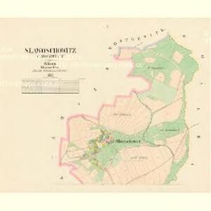
Kosmatschow (Kozmačow) - c3355-1-002 - Kaiserpflichtexemplar der Landkarten des stabilen Katasters
1 : 2880
Kosmatschow (Kozmačow) - c3355-1-001 - Kaiserpflichtexemplar der Landkarten des stabilen Katasters
1 : 2880

III. vojenské mapování 4250/2
1 : 25000
Soubor přehledných map pro plánování a statistiku: 4251 – Horažďovice

Podrobné mapy zemí Koruny české v měřítku 1:75.000 a mapy vzdáleností všech míst při silnici ležících
1 : 75000 Klatovy (Česko : oblast) Bělohlav, Josef F. Topič
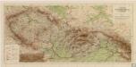
III. vojenské mapování 4250
1 : 75000
Klatovy a okolí
1 : 75000 Klatovy (Česko : oblast) Vojenský zeměpisný ústav
Klatovy a okolí
1 : 75000 Klatovy (Česko : oblast) Vojenský zeměpisný ústav

Horažďovice
1 : 75000 Horažďovice-oblast (Česko) Vojenský zeměpisný ústav
Horažďovice
1 : 75000 Horažďovice (Česko : oblast) Vojenský zeměpisný ústav
Horažďovice
1 : 75000 Horažďovice (Česko : oblast) Vojenský zeměpisný ústav
Taus und Klattau
1 : 75000 Domažlice (Česko : oblast) K. u. k. Militärgeographisches Institut
Podrobná mapa Království českého
1 : 100000 Klatovy (Česko : oblast) Srp, Jan Jaroslav Bursík
Podrobná místopisná mapa Království Českého
Příruční mapa Československé republiky

Okresní hejtmanství Klatovské
1 : 100000 Klatovy-oblast (Česko) Srp, Jan Jos. R. Vilímek
Nepomuk und Horazdowitz.
from Spezialkarte der osterreichisch-ungarischen Monarchie.
Spezial Karte von Böhmen