Maps of Trstěnice

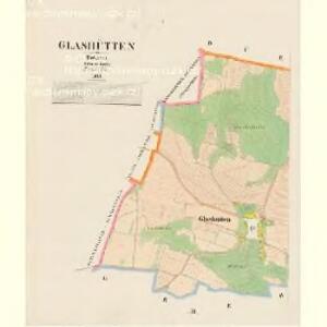
Glashütten - c6930-1-002 - Kaiserpflichtexemplar der Landkarten des stabilen Katasters
1 : 2880
Glashütten - c6930-1-001 - Kaiserpflichtexemplar der Landkarten des stabilen Katasters
1 : 2880
Oberdorf - c2171-1-002 - Kaiserpflichtexemplar der Landkarten des stabilen Katasters
1 : 2880
Oberdorf - c2171-1-003 - Kaiserpflichtexemplar der Landkarten des stabilen Katasters
1 : 2880
Oberdorf - c2171-1-001 - Kaiserpflichtexemplar der Landkarten des stabilen Katasters
1 : 2880
Katastrální mapa obce Tři Sekery WC-XV-18 be
1 : 2880
Hospodářská a porostní mapa revíru Plánská Huť
1 : 2880
Hospodářská a porostní mapa revíru Plánská Huť
1 : 2880
Entwurff der freyherrl. Haimhausischen Herrshafft Kuttenplan wie solche anno 1676 in Esse sich befunden
Chodová Planá-oblast (Česko)
Gradkartenblatt
1 : 25000 Mariánské Lázně-oblast (Česko) Böhm, Karl
[Kartenblatt]
1 : 25000 Chodová Planá (Česko : oblast) Reichsamt für Landesaufnahme
III. vojenské mapování 4049/2
1 : 25000

Umgebungskarte von Marienbad
1 : 25000 Mariánské Lázně (Česko : oblast) R. Lechner's k. u. k. Hof.- u. Univ.- Buchhandl. (Wilhelm Müller)
Umgebungskarte von Marienbad
1 : 25000 Mariánské Lázně (Česko : oblast) Franz Gschihay
Rundansicht von dem Basaltberge Podhorn (2634 Wien. Fuss) auf der Herrschaft Tepl bei Marienbad
Mariánské Lázně-oblast (Česko) Frey, Paul
Rundansicht von dem Basaltberge Podhorn (833 Meter) auf der Herrschaft Tepl bei Marienbad
Mariánské Lázně-oblast (Česko) F.A. Götz
Umgebungskarte der Curstadt Marienbad
1 : 60000 Mariánské Lázně-oblast (Česko) E.A. Götz
Umgebungskarte der Kurstadt Marienbad
1 : 50000 Mariánské Lázně-oblast (Česko) E.A. Götz
Hayder Vicariat
Bor-oblast (Tachov, Česko)
Marienbad und Tachau
1 : 75000 Mariánské Lázně (Česko : oblast) Höller, K. K. u. k. Militärgeographisches Institut
Marienbad und Tachau
1 : 75000 Mariánské Lázně (Česko : oblast) K. u. k. Militärgeographisches Institut
Přehledová mapa velkostatku Tachov
1 : 17280
Mariánské Lázně
1 : 75000 Chodová Planá (Česko : oblast) Vojenský zeměpisný ústav
Mariánské Lázně
1 : 75000 Mariánské Lázně (Česko : oblast) Vojenský zeměpisný ústav
Mariánské Lázně
1 : 75000 Mariánské Lázně-oblast (Česko) Vojenský zeměpisný ústav
III. vojenské mapování 4049
1 : 75000
Vilímkovy místopisné mapy zemí Koruny české
1 : 100000 Chodová Planá (Česko : oblast) Srp, Jan Jos. R. Vilímek
Marienbad und Tachau.
from Spezialkarte der osterreichisch-ungarischen Monarchie.