Maps of Křičeň

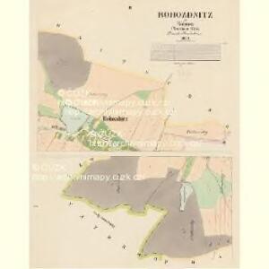
Rohozdnitz - c6509-1-001 - Kaiserpflichtexemplar der Landkarten des stabilen Katasters
1 : 2880
Rohozdnitz - c6509-1-002 - Kaiserpflichtexemplar der Landkarten des stabilen Katasters
1 : 2880
Indikační skica mapy stabilního katastru pro obec Osičky III.
1 : 2880
Porostní mapa revíru Kasalice Sekce IV.
1 : 2880
Indikační skica mapy stabilního katastru pro obec Dolany II.
1 : 2880
Wositschek - c5535-1-001 - Kaiserpflichtexemplar der Landkarten des stabilen Katasters
1 : 2880
Wositschek - c5535-1-002 - Kaiserpflichtexemplar der Landkarten des stabilen Katasters
1 : 2880
Wositschek - c5535-1-003 - Kaiserpflichtexemplar der Landkarten des stabilen Katasters
1 : 2880
Křitschen (Křiczen) - c3642-1-002 - Kaiserpflichtexemplar der Landkarten des stabilen Katasters
1 : 2880
Křitschen (Křiczen) - c3642-1-003 - Kaiserpflichtexemplar der Landkarten des stabilen Katasters
1 : 2880
Křitschen (Křiczen) - c3642-1-001 - Kaiserpflichtexemplar der Landkarten des stabilen Katasters
1 : 2880
Indikační skica mapy stabilního katastru pro obec Křičeň I.
1 : 2880
Porostní mapa obecního lesa Křičeňského
1 : 2880
Indikační skica mapy stabilního katastru pro obec Osice III.
1 : 2880
Indikační skica mapy stabilního katastru pro obec Dolany I.
1 : 2880
Indikační skica mapy stabilního katastru pro obec Křičeň I.-IV.
1 : 2880
Indikační skica mapy stabilního katastru pro obec Osice I.-IV.
1 : 2880
Mapa revíru Kasalice
1 : 10000
Dollan - c1239-1-004 - Kaiserpflichtexemplar der Landkarten des stabilen Katasters
1 : 2880
Dollan - c1239-1-003 - Kaiserpflichtexemplar der Landkarten des stabilen Katasters
1 : 2880
Dollan - c1239-1-002 - Kaiserpflichtexemplar der Landkarten des stabilen Katasters
1 : 2880
Dollan - c1239-1-001 - Kaiserpflichtexemplar der Landkarten des stabilen Katasters
1 : 2880
Indikační skica mapy stabilního katastru pro obec Právy I.-IV.
1 : 2880
Dobrzenitz (Dobřenice) - c1208-1-005 - Kaiserpflichtexemplar der Landkarten des stabilen Katasters
1 : 2880
Dobrzenitz (Dobřenice) - c1208-1-001 - Kaiserpflichtexemplar der Landkarten des stabilen Katasters
1 : 2880
Dobrzenitz (Dobřenice) - c1208-1-002 - Kaiserpflichtexemplar der Landkarten des stabilen Katasters
1 : 2880
Dobrzenitz (Dobřenice) - c1208-1-004 - Kaiserpflichtexemplar der Landkarten des stabilen Katasters
1 : 2880
Dobrzenitz (Dobřenice) - c1208-1-003 - Kaiserpflichtexemplar der Landkarten des stabilen Katasters
1 : 2880
Indikační skica mapy stabilního katastru pro obec Právy II., IV
1 : 2880