Maps of Nová Paka

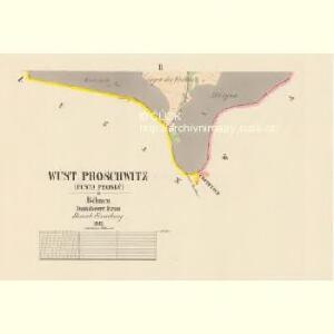
Wüst Proschwitz (Pusta Proseč) - c6286-1-001 - Kaiserpflichtexemplar der Landkarten des stabilen Katasters
1 : 2880
Wüst Proschwitz (Pusta Proseč) - c6286-1-002 - Kaiserpflichtexemplar der Landkarten des stabilen Katasters
1 : 2880
Stabilní katastr - Procovní otisk Waldau...

Studinka - c7509-1-002 - Kaiserpflichtexemplar der Landkarten des stabilen Katasters
1 : 2880
Studinka - c7509-1-001 - Kaiserpflichtexemplar der Landkarten des stabilen Katasters
1 : 2880
Waldau (Waldow) - c8311-1-001 - Kaiserpflichtexemplar der Landkarten des stabilen Katasters
1 : 2880
Waldau (Waldow) - c8311-1-002 - Kaiserpflichtexemplar der Landkarten des stabilen Katasters
1 : 2880
Waldau (Waldow) - c8311-1-003 - Kaiserpflichtexemplar der Landkarten des stabilen Katasters
1 : 2880
Augezd - c3690-1-002 - Kaiserpflichtexemplar der Landkarten des stabilen Katasters
1 : 2880
Augezd - c3690-1-001 - Kaiserpflichtexemplar der Landkarten des stabilen Katasters
1 : 2880
Bestandeskarte der Forste Bělohrad
1 : 10000 Lázně Bělohrad (Česko : oblast)
Bestandeskarte der Forste Bjelohrad
1 : 10000 Lázně Bělohrad (Česko : oblast)
Bestandeskarte der Forste Bjelohrad
1 : 10000 Lázně Bělohrad (Česko : oblast)
Bestandeskarte der Forste Bělohrad
1 : 10000 Lázně Bělohrad (Česko : oblast)
Bestandeskarte der Forste Bělohrad
1 : 10000 Lázně Bělohrad (Česko : oblast)
[Kartenblatt]
1 : 25000 Jičín (Česko : oblast) Reichsamt für Landesaufnahme
Gradkartenblatt
1 : 25000 Jičín-oblast (Česko) Bellschan, Anton
III. vojenské mapování 3855/1
1 : 25000
Mapa politického a školního okresu Hradce Králové


Podrobné mapy zemí Koruny české v měřítku 1:75.000 a mapa vzdáleností všech míst při silnici ležících - Turnov - Sobotka - Jičín - Paka. Průvodce statisticko-historický po všech místech na těchto mapách uvedených a rejstřík věcný názvů hor, potoků, řek, rybníků atd. Sešit 15. List 79,
1 : 75000
Jičín a okolí
1 : 75000 Jičín (Česko : oblast) Vojenský zeměpisný ústav
III. vojenské mapování 3855
1 : 75000
Jičín
1 : 75000 Dvůr Králové nad Labem (Česko : oblast) Vojenský zeměpisný ústav
Hořitz und Jičin
1 : 75000 Dvůr Králové nad Labem (Česko : oblast) Richter K. u. k. militär-geographisches Institut
Hořitz und Jičin
1 : 75000 Dvůr Králové nad Labem (Česko : oblast) Richter K. u. k. Militärgeographisches Institut
Hořitz und Jičin
1 : 75000 Hořice (Jičín, Česko : oblast) K. u. k. Militärgeographisches Institut
Podrobná mapa Království českého
1 : 100000 Dvůr Králové nad Labem (Česko : oblast) Srp, Jan Jaroslav Bursík
Vilímkovy místopisné mapy zemí Koruny české
1 : 100000 Dvůr Králové nad Labem (Česko : oblast) Srp, Jan Jos. R. Vilímek