Maps of Plch

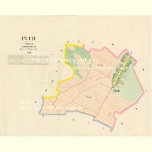
Plch - c5835-1-001 - Kaiserpflichtexemplar der Landkarten des stabilen Katasters
1 : 2880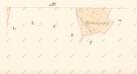
Indikační skica mapy stabilního katastru pro obec Osice ad IV.
1 : 2880
Indikační skica mapy stabilního katastru pro obec Plch I.
1 : 2880
Koncept mapy pozemků bývalého Ždánického rybníka
1 : 2520
Indikační skica mapy stabilního katastru pro obec Dolany III.
1 : 2880
Indikační skica mapy stabilního katastru pro obec Staré Ždánice a osadu Nové Ždánice I.-V.
1 : 2880
Indikační skica mapy stabilního katastru pro obec Staré Ždánice a osadu Nové Ždánice III.
1 : 2880
Indikační skica mapy stabilního katastru pro obec Staré Ždánice a osadu Nové Ždánice I.-V.
1 : 2880
Dollan - c1239-1-004 - Kaiserpflichtexemplar der Landkarten des stabilen Katasters
1 : 2880
Dollan - c1239-1-003 - Kaiserpflichtexemplar der Landkarten des stabilen Katasters
1 : 2880
Dollan - c1239-1-002 - Kaiserpflichtexemplar der Landkarten des stabilen Katasters
1 : 2880
Dollan - c1239-1-001 - Kaiserpflichtexemplar der Landkarten des stabilen Katasters
1 : 2880
Wossitz - c5534-1-002 - Kaiserpflichtexemplar der Landkarten des stabilen Katasters
1 : 2880
Wossitz - c5534-1-001 - Kaiserpflichtexemplar der Landkarten des stabilen Katasters
1 : 2880
Wossitz - c5534-1-003 - Kaiserpflichtexemplar der Landkarten des stabilen Katasters
1 : 2880
Indikační skica mapy stabilního katastru pro obec Osice I.-IV.
1 : 2880
Zdanitz - c7283-1-002 - Kaiserpflichtexemplar der Landkarten des stabilen Katasters
1 : 2880
Zdanitz - c7283-1-003 - Kaiserpflichtexemplar der Landkarten des stabilen Katasters
1 : 2880
Zdanitz - c7283-1-004 - Kaiserpflichtexemplar der Landkarten des stabilen Katasters
1 : 2880
Zdanitz - c7283-1-001 - Kaiserpflichtexemplar der Landkarten des stabilen Katasters
1 : 2880
Indikační skica mapy stabilního katastru pro obec Osice IV.
1 : 2880
Porostní mapa revíru Stéblové
1 : 10000
Mapa polesí Stéblová
1 : 15000

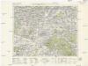
Gradkartenblatt
1 : 25000 Hradec Králové-oblast (Česko) Hallada, Alois
Geometrische Karte von der Herrschaft Chlumetz
1 : 87000 Chlumec nad Cidlinou-oblast (Česko) Langweil, Antonín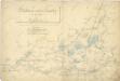
Některé vodní stavby z 15. a 16. století na Pardubicku

Pardubice
1 : 75000 Hradec Králové (Česko : oblast) Vojenský zeměpisný ústav
8. Kraj Pardubický
Königgrätz u. Umgebung
1 : 75000 Hradec Králové (Česko : oblast) Landesvermessungsamt Böhmen u. Mähren