Maps of Zlatá Koruna

Pleschowitz - c5830-1-001 - Kaiserpflichtexemplar der Landkarten des stabilen Katasters
1 : 2880
Pleschowitz - c5830-1-002 - Kaiserpflichtexemplar der Landkarten des stabilen Katasters
1 : 2880
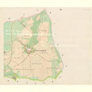
Goldenkron - c9272-1-002 - Kaiserpflichtexemplar der Landkarten des stabilen Katasters
1 : 2880
Goldenkron - c9272-1-001 - Kaiserpflichtexemplar der Landkarten des stabilen Katasters
1 : 2880
Hollubau - c1978-1-009 - Kaiserpflichtexemplar der Landkarten des stabilen Katasters
1 : 2880
Hollubau - c1978-1-008 - Kaiserpflichtexemplar der Landkarten des stabilen Katasters
1 : 2880
Hollubau - c1978-1-001 - Kaiserpflichtexemplar der Landkarten des stabilen Katasters
1 : 2880
Hollubau - c1978-1-006 - Kaiserpflichtexemplar der Landkarten des stabilen Katasters
1 : 2880
Hollubau - c1978-1-004 - Kaiserpflichtexemplar der Landkarten des stabilen Katasters
1 : 2880
Hollubau - c1978-1-005 - Kaiserpflichtexemplar der Landkarten des stabilen Katasters
1 : 2880
Hollubau - c1978-1-002 - Kaiserpflichtexemplar der Landkarten des stabilen Katasters
1 : 2880
Hollubau - c1978-1-007 - Kaiserpflichtexemplar der Landkarten des stabilen Katasters
1 : 2880
Hollubau - c1978-1-003 - Kaiserpflichtexemplar der Landkarten des stabilen Katasters
1 : 2880
Przisnitz - c6247-1-003 - Kaiserpflichtexemplar der Landkarten des stabilen Katasters
1 : 2880
Przisnitz - c6247-1-004 - Kaiserpflichtexemplar der Landkarten des stabilen Katasters
1 : 2880
Przisnitz - c6247-1-007 - Kaiserpflichtexemplar der Landkarten des stabilen Katasters
1 : 2880
Przisnitz - c6247-1-006 - Kaiserpflichtexemplar der Landkarten des stabilen Katasters
1 : 2880
Przisnitz - c6247-1-008 - Kaiserpflichtexemplar der Landkarten des stabilen Katasters
1 : 2880
Przisnitz - c6247-1-009 - Kaiserpflichtexemplar der Landkarten des stabilen Katasters
1 : 2880
Przisnitz - c6247-1-005 - Kaiserpflichtexemplar der Landkarten des stabilen Katasters
1 : 2880
Przisnitz - c6247-1-002 - Kaiserpflichtexemplar der Landkarten des stabilen Katasters
1 : 2880
Przisnitz - c6247-1-001 - Kaiserpflichtexemplar der Landkarten des stabilen Katasters
1 : 2880
Sticks - c7767-1-001 - Kaiserpflichtexemplar der Landkarten des stabilen Katasters
1 : 2880
Sticks - c7767-1-002 - Kaiserpflichtexemplar der Landkarten des stabilen Katasters
1 : 2880
Bestandeskarte der zum Plansker Complexe der Herrschaft Krumau gehörigen Reviere Neuhof u. Mistelholz
1 : 20000 Borová (Chvalšiny, Česko) Meinhard, Carl

[Mapový list]
1 : 25000 Zvíkovské Podhradí-oblast (Česko) Vojenský zeměpisný ústav
Schulwandkarte des politischen Bezirkes Krumau Blatt 2

České Budějovice a okolí
1 : 75000 České Budějovice (Česko : oblast) Vojenský zeměpisný ústav