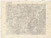
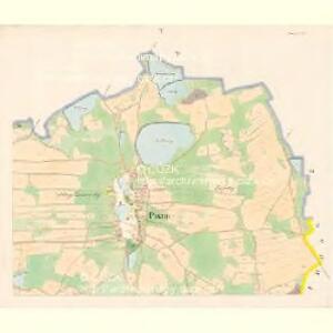
Maps of Pístina

Pistin - c5785-1-006 - Kaiserpflichtexemplar der Landkarten des stabilen Katasters
1 : 2880
Pistin - c5785-1-001 - Kaiserpflichtexemplar der Landkarten des stabilen Katasters
1 : 2880
Pistin - c5785-1-003 - Kaiserpflichtexemplar der Landkarten des stabilen Katasters
1 : 2880
Pistin - c5785-1-002 - Kaiserpflichtexemplar der Landkarten des stabilen Katasters
1 : 2880
Pistin - c5785-1-005 - Kaiserpflichtexemplar der Landkarten des stabilen Katasters
1 : 2880
Pistin - c5785-1-004 - Kaiserpflichtexemplar der Landkarten des stabilen Katasters
1 : 2880
Mlaka - c4751-1-001 - Kaiserpflichtexemplar der Landkarten des stabilen Katasters
1 : 2880
Mlaka - c4751-1-004 - Kaiserpflichtexemplar der Landkarten des stabilen Katasters
1 : 2880
Mlaka - c4751-1-003 - Kaiserpflichtexemplar der Landkarten des stabilen Katasters
1 : 2880
Mlaka - c4751-1-002 - Kaiserpflichtexemplar der Landkarten des stabilen Katasters
1 : 2880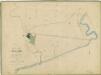
Hospodářská mapa polesí Mláka 1
1 : 2880
Mapy činžovních pozemků II. sekce třeboňského velkostatku pro obce Dolní Slověnice, Dunajovice, Klec, Kolence, Lomnice, Lužnice, Mláka, Novosedly, Přeseka, Smržov, Stará Hlína 1
1 : 2880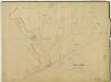
Hospodářská mapa polesí Mláka 1
1 : 2880
Půdorysný plán mlýna na řece Lužnici 1
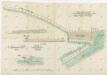
Plán splavu a zpevnění břehu u mláckého mlýna na Nové řece 1
1 : 100
Situační plán pozemku pronajatého pro zřízení lesního tábora pí. B. Friedländerové 1
1 : 2880
kopie-Mapy činžovních pozemků III. sekce třeboňského velkostatku pro obce: Břilice, Domanín, Herda, Holičky, Kojákovice, Spolí, Třeboň 1
1 : 2880
Porostní mapa polesí Mláka 1

Platz - c7407-1-002 - Kaiserpflichtexemplar der Landkarten des stabilen Katasters
1 : 2880
Platz - c7407-1-005 - Kaiserpflichtexemplar der Landkarten des stabilen Katasters
1 : 2880
Platz - c7407-1-001 - Kaiserpflichtexemplar der Landkarten des stabilen Katasters
1 : 2880
Platz - c7407-1-004 - Kaiserpflichtexemplar der Landkarten des stabilen Katasters
1 : 2880
Platz - c7407-1-003 - Kaiserpflichtexemplar der Landkarten des stabilen Katasters
1 : 2880
Porostní mapa polesí Mláka 1
1 : 10000
Generální mapa panství Třeboň a inkorporovaných statků Bzí, Lomnice, Borovany, Třeboň, Hamr a Val 1

Mapy činžovních pozemků II. sekce třeboňského velkostatku pro obce: Dolní Slověnice, Dunajovice, Klec, Kolence, Lomnice, Lužnice, Mláka, Novosedly. Smržov, Stará Hlína 1

Geometrický plán lesů Na dalekých a U Kletišťat,rybníků Starý Vdovec a Melounek a přilehlých činžovních a deputátních pozemků 1

Mapa porostů revírů Mlaka & Paseka
Mláka (Novosedly nad Nežárkou, Česko) Buchtele, Fr.
Mapa panství Stráž s hranicemi pantví třeboňského, novobystřického a jindřichohradeckého