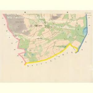
Maps of Hroznětín

Edersgrün - c5369-1-003 - Kaiserpflichtexemplar der Landkarten des stabilen Katasters
1 : 2880
Edersgrün - c5369-1-001 - Kaiserpflichtexemplar der Landkarten des stabilen Katasters
1 : 2880
Edersgrün - c5369-1-002 - Kaiserpflichtexemplar der Landkarten des stabilen Katasters
1 : 2880
Tüppelsgrün - c1108-1-002 - Kaiserpflichtexemplar der Landkarten des stabilen Katasters
1 : 2880
Tüppelsgrün - c1108-1-004 - Kaiserpflichtexemplar der Landkarten des stabilen Katasters
1 : 2880
Tüppelsgrün - c1108-1-003 - Kaiserpflichtexemplar der Landkarten des stabilen Katasters
1 : 2880
Tüppelsgrün - c1108-1-001 - Kaiserpflichtexemplar der Landkarten des stabilen Katasters
1 : 2880
Tüppelsgrün - c1108-1-005 - Kaiserpflichtexemplar der Landkarten des stabilen Katasters
1 : 2880
Kammersgrün - c4326-3-003 - Kaiserpflichtexemplar der Landkarten des stabilen Katasters
1 : 2880
Kammersgrün - c4326-3-002 - Kaiserpflichtexemplar der Landkarten des stabilen Katasters
1 : 2880
Kammersgrün - c4326-3-001 - Kaiserpflichtexemplar der Landkarten des stabilen Katasters
1 : 2880
Ruppelsgrün - c6629-1-002 - Kaiserpflichtexemplar der Landkarten des stabilen Katasters
1 : 2880
Ruppelsgrün - c6629-1-001 - Kaiserpflichtexemplar der Landkarten des stabilen Katasters
1 : 2880

Uibersichtskarte der neuen Eintheilung des Koenigreiches Boehmen

Karlsbader Bezirkskarte
1 : 75000 Karlovy Vary-oblast (Česko) Kutschera, G. G. Kutschera
Lichtenstädter Vikariat
Hroznětín (Karlovy Vary, Česko)
Morphologische Uebersichtskarte des Falkenauer Tertiärbeckens
1 : 120000 Sokolov (Česko : oblast) Peter, Josef
Kaaden und Joachimsthal
1 : 75000 Jáchymov (Karlovy Vary, Česko : oblast) Leitner K. u. k. militär-geographisches Institut
Kaaden und Joachimsthal
1 : 75000 Jáchymov (Karlovy Vary, Česko : oblast) Leitner K. u. k. Militärgeographisches Institut
Kaaden und Joachimsthal
1 : 75000 Jáchymov (Karlovy Vary, Česko : oblast) K. u. k. Militärgeographisches Institut
Ostrov u Karlových Varů a okolí
1 : 75000 Karlovy Vary (Česko : oblast) Vojenský zeměpisný ústav
Graslitz und Johanngeorgenstadt
1 : 75000 Johanngeorgenstadt (Německo : oblast) Höller, K. K. u. k. militär-geographisches Institut
Graslitz und Johanngeorgenstadt
1 : 75000 Johanngeorgenstadt (Německo : oblast) Höller, K. K. u. k. Militärgeographisches Institut
Graslitz und Johanngeorgenstadt
1 : 75000 Johanngeorgenstadt (Německo : oblast) K. u. k. Militärgeographisches Institut
Podrobná mapa Království českého
1 : 100000 Jáchymov (Karlovy Vary, Česko : oblast) Srp, Jan Jos. R. Vilímek
[Vilímkovy místopisné mapy zemí Koruny české]
1 : 100000 Jáchymov (Karlovy Vary, Česko : oblast) Srp, Jan Jos. R. Vilímek
Mapy plánování ČSR

Graslitz und Johanngeorgenstadt.
from Spezialkarte der osterreichisch-ungarischen Monarchie.