Maps of Staré Buky

Kaltenhof - c5344-1-002 - Kaiserpflichtexemplar der Landkarten des stabilen Katasters
1 : 2880
Kaltenhof - c5344-1-001 - Kaiserpflichtexemplar der Landkarten des stabilen Katasters
1 : 2880
Mittel-Altenbuch (Prostředni-Stary-Buka) - c6136-1-002 - Kaiserpflichtexemplar der Landkarten des stabilen Katasters
1 : 2880
Mittel-Altenbuch (Prostředni-Stary-Buka) - c6136-1-003 - Kaiserpflichtexemplar der Landkarten des stabilen Katasters
1 : 2880
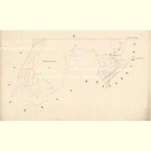
Mittel-Altenbuch (Prostředni-Stary-Buka) - c6136-1-001 - Kaiserpflichtexemplar der Landkarten des stabilen Katasters
1 : 2880
Mittel-Altenbuch (Prostředni-Stary-Buka) - c6136-1-004 - Kaiserpflichtexemplar der Landkarten des stabilen Katasters
1 : 2880
Weigelsdorf - c8750-1-003 - Kaiserpflichtexemplar der Landkarten des stabilen Katasters
1 : 2880
Weigelsdorf - c8750-1-001 - Kaiserpflichtexemplar der Landkarten des stabilen Katasters
1 : 2880
Weigelsdorf - c8750-1-002 - Kaiserpflichtexemplar der Landkarten des stabilen Katasters
1 : 2880
Nieder-Altenbuch (Dolnistarybuka) - c1392-1-003 - Kaiserpflichtexemplar der Landkarten des stabilen Katasters
1 : 2880
Nieder-Altenbuch (Dolnistarybuka) - c1392-1-004 - Kaiserpflichtexemplar der Landkarten des stabilen Katasters
1 : 2880
Nieder-Altenbuch (Dolnistarybuka) - c1392-1-001 - Kaiserpflichtexemplar der Landkarten des stabilen Katasters
1 : 2880
Nieder-Altenbuch (Dolnistarybuka) - c1392-1-002 - Kaiserpflichtexemplar der Landkarten des stabilen Katasters
1 : 2880
[Trautenau und Umgebung]
1 : 25000 Trutnov (Česko : oblast)
Bez titulu: Soubor plánů – Prusko-Rakouská válka 1866

III. vojenské mapování 3756/3
1 : 25000
[Kartenblatt]
1 : 25000 Mladé Buky (Česko : oblast) Reichsamt für Landesaufnahme


Neueste Wegekarte vom Riesengebirge und Situationsplan von Johannsbad
1 : 75000 Janské Lázně (Česko : oblast) Vatter, Alfred Alfred Vatter
Topographische und Militairische Carte desienigen Theils von Boehmen...

Úpice a okolí

Trutnov
1 : 75000 Trutnov (Česko : oblast) Vojenský zeměpisný ústav
Trutnov
1 : 75000 Trutnov-oblast (Česko) Vojenský zeměpisný ústav
Trutnov
1 : 75000 Trutnov (Česko : oblast) Vojenský zeměpisný ústav
Trautenau und Politz
1 : 75000 Broumov (Náchod, Česko : oblast) Fenzl K. u. k. Militärgeographisches Institut
Trautenau und Politz
1 : 75000 Police nad Metují (Česko : oblast) K. u. k. Militärgeographisches Institut
Trutnov a okolí

Trutnov a okolí
1 : 75000 Trutnov (Česko : oblast) Vojenský zeměpisný ústav