Maps of Ostřešany

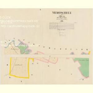
Nemoschitz - c5030-1-002 - Kaiserpflichtexemplar der Landkarten des stabilen Katasters
1 : 2880
Nemoschitz - c5030-1-004 - Kaiserpflichtexemplar der Landkarten des stabilen Katasters
1 : 2880
Nemoschitz - c5030-1-003 - Kaiserpflichtexemplar der Landkarten des stabilen Katasters
1 : 2880
Nemoschitz - c5030-1-001 - Kaiserpflichtexemplar der Landkarten des stabilen Katasters
1 : 2880
Koncept pozemků bývalého Nemošického rybníka, tam zbudované drenáže a hřebčína
1 : 3647
Mapa pozemků a drenáže na území bývalého Nemošického rybníka
1 : 3337
Indikační skica mapy stabilního katastru pro obec Nemošice IV.
1 : 2880
Indikační skica mapy stabilního katastru pro obec Drozdice II.
1 : 2880
Drozditz - c1540-1-002 - Kaiserpflichtexemplar der Landkarten des stabilen Katasters
1 : 2880
Drozditz - c1540-1-001 - Kaiserpflichtexemplar der Landkarten des stabilen Katasters
1 : 2880
Indikační skica mapy stabilního katastru pro obec Mnětice I.
1 : 2880
Indikační skica mapy stabilního katastru pro obec Dražkovice II.
1 : 2880
Indikační skica mapy stabilního katastru pro obec Pardubičky ad II.
1 : 2880
Indikační skica mapy stabilního katastru pro obec Dražkovice I.-IV.
1 : 2880
Draschkowitz - c1522-1-003 - Kaiserpflichtexemplar der Landkarten des stabilen Katasters
1 : 2880
Draschkowitz - c1522-1-002 - Kaiserpflichtexemplar der Landkarten des stabilen Katasters
1 : 2880
Draschkowitz - c1522-1-001 - Kaiserpflichtexemplar der Landkarten des stabilen Katasters
1 : 2880
Indikační skica mapy stabilního katastru pro obec Ostřešany I., II.
1 : 2880
Pardubitschek - c5634-1-002 - Kaiserpflichtexemplar der Landkarten des stabilen Katasters
1 : 2880
Pardubitschek - c5634-1-001 - Kaiserpflichtexemplar der Landkarten des stabilen Katasters
1 : 2880
Indikační skica mapy stabilního katastru pro obec Dražkovice I.
1 : 2880
Indikační skica mapy stabilního katastru pro obec Dražkovice III., IV.
1 : 2880
Indikační skica mapy stabilního katastru pro obec Pardubičky I., ad II., III.
1 : 2880
Waldbestandskarte des zur kais. könig. Kameralherrschaft Pardubitz gehörigen Mietitzer Reviers
1 : 3000 Pardubice-oblast (Česko) Jiřička, Josef
Indikační skica mapy stabilního katastru pro obec Ostřešany I.-VI.
1 : 2880
Indikační skica mapy stabilního katastru pro obec Mnětice I.-VI.
1 : 2880
Pardubitz - c5633-1-006 - Kaiserpflichtexemplar der Landkarten des stabilen Katasters
1 : 2880
Pardubitz - c5633-1-007 - Kaiserpflichtexemplar der Landkarten des stabilen Katasters
1 : 2880
Pardubitz - c5633-1-003 - Kaiserpflichtexemplar der Landkarten des stabilen Katasters
1 : 2880
Pardubitz - c5633-1-009 - Kaiserpflichtexemplar der Landkarten des stabilen Katasters
1 : 2880
Pardubitz - c5633-1-011 - Kaiserpflichtexemplar der Landkarten des stabilen Katasters
1 : 2880
Pardubitz - c5633-1-005 - Kaiserpflichtexemplar der Landkarten des stabilen Katasters
1 : 2880
Pardubitz - c5633-1-002 - Kaiserpflichtexemplar der Landkarten des stabilen Katasters
1 : 2880
Pardubitz - c5633-1-004 - Kaiserpflichtexemplar der Landkarten des stabilen Katasters
1 : 2880
Pardubitz - c5633-1-001 - Kaiserpflichtexemplar der Landkarten des stabilen Katasters
1 : 2880
Pardubitz - c5633-1-010 - Kaiserpflichtexemplar der Landkarten des stabilen Katasters
1 : 2880