Maps of Kostelec

Nedraschitz (Nedražice) - c5000-1-001 - Kaiserpflichtexemplar der Landkarten des stabilen Katasters
1 : 2880
Nedraschitz (Nedražice) - c5000-1-003 - Kaiserpflichtexemplar der Landkarten des stabilen Katasters
1 : 2880
Nedraschitz (Nedražice) - c5000-1-002 - Kaiserpflichtexemplar der Landkarten des stabilen Katasters
1 : 2880
Guratin (Krtino) - c3580-1-002 - Kaiserpflichtexemplar der Landkarten des stabilen Katasters
1 : 2880
Guratin (Krtino) - c3580-1-001 - Kaiserpflichtexemplar der Landkarten des stabilen Katasters
1 : 2880
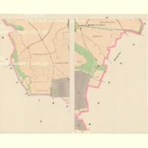
Honositz (Honosoic) - c1987-1-002 - Kaiserpflichtexemplar der Landkarten des stabilen Katasters
1 : 2880
Honositz (Honosoic) - c1987-1-004 - Kaiserpflichtexemplar der Landkarten des stabilen Katasters
1 : 2880
Honositz (Honosoic) - c1987-1-003 - Kaiserpflichtexemplar der Landkarten des stabilen Katasters
1 : 2880
Honositz (Honosoic) - c1987-1-001 - Kaiserpflichtexemplar der Landkarten des stabilen Katasters
1 : 2880
Honositz (Honosoic) - c1987-1-006 - Kaiserpflichtexemplar der Landkarten des stabilen Katasters
1 : 2880
Honositz (Honosoic) - c1987-1-005 - Kaiserpflichtexemplar der Landkarten des stabilen Katasters
1 : 2880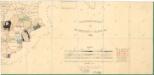
Přehledová mapa velkostatku Kladruby
1 : 17280
Katastrální mapa obce Kostelec
1 : 2880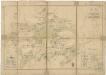
Plán dvora Zálezly
1 : 6018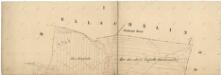
Katastrální mapa obce Krtín
1 : 2880
[Kartenblatt]
1 : 25000 Heřmanova Huť (Česko : oblast) Reichsamt für Landesaufnahme

III. vojenské mapování 4150/1
1 : 25000
Gradkartenblatt
1 : 25000 Kladruby-oblast (Tachov, Česko) Boruszczak, Theodor
Přehledová mapa velkostatku Kladruby
1 : 52300

Mieser Vicariat
Stříbro-oblast (Česko)
Bischofteinitz und Nürschan
1 : 75000 Horšovský Týn (Česko : oblast) Mulacz, J. K. u. k. militär-geographisches Institut
Bischofteinitz und Nürschan
1 : 75000 Horšovský Týn (Česko : oblast) Mulacz, J. K. u. k. Militärgeographisches Institut
Bischofteinitz und Nürschan
1 : 75000 Horšovský Týn (Česko : oblast) K. u. k. Militärgeographisches Institut
III. vojenské mapování 4150
1 : 75000
Stříbro a okolí
1 : 75000 Stříbro (Česko : oblast) Vojenský zeměpisný ústav
Horšovský Týn
1 : 75000 Horšovský Týn-oblast (Česko) Vojenský zeměpisný ústav
Podrobná mapa Království českého
1 : 100000 Planá (Tachov, Česko : oblast) Srp, Jan Jaroslav Bursík