Maps of Náchod

Nachod - c4950-1-002 - Kaiserpflichtexemplar der Landkarten des stabilen Katasters
1 : 2880
Nachod - c4950-1-004 - Kaiserpflichtexemplar der Landkarten des stabilen Katasters
1 : 2880
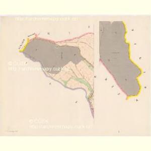
Nachod - c4950-1-001 - Kaiserpflichtexemplar der Landkarten des stabilen Katasters
1 : 2880
Nachod - c4950-1-003 - Kaiserpflichtexemplar der Landkarten des stabilen Katasters
1 : 2880
Nachod - c4950-1-005 - Kaiserpflichtexemplar der Landkarten des stabilen Katasters
1 : 2880
Nachod (Náchod)

Altstadt (Stare Město) - c7267-1-002 - Kaiserpflichtexemplar der Landkarten des stabilen Katasters
1 : 2880
Altstadt (Stare Město) - c7267-1-001 - Kaiserpflichtexemplar der Landkarten des stabilen Katasters
1 : 2880
Dobroschow in Böhmen
1 : 2880 Dobrošov (Náchod, Česko)
Baby - c0039-1-001 - Kaiserpflichtexemplar der Landkarten des stabilen Katasters
1 : 2880
Baby - c0039-1-002 - Kaiserpflichtexemplar der Landkarten des stabilen Katasters
1 : 2880
Bilowes - c0201-1-003 - Kaiserpflichtexemplar der Landkarten des stabilen Katasters
1 : 2880
Bilowes - c0201-1-002 - Kaiserpflichtexemplar der Landkarten des stabilen Katasters
1 : 2880
Bilowes - c0201-1-001 - Kaiserpflichtexemplar der Landkarten des stabilen Katasters
1 : 2880
Nieder Radechow (Dolnj Radechow) - c1370-1-002 - Kaiserpflichtexemplar der Landkarten des stabilen Katasters
1 : 2880
Nieder Radechow (Dolnj Radechow) - c1370-1-001 - Kaiserpflichtexemplar der Landkarten des stabilen Katasters
1 : 2880
Nieder Radechow (Dolnj Radechow) - c1370-1-003 - Kaiserpflichtexemplar der Landkarten des stabilen Katasters
1 : 2880
Plan des Gefechtsfeldes von Nachod, Skalitz und Schweinschaedel am 27, 28 u. 29. Juni 1866
1 : 25000 Náchod-oblast (Česko) Baumann
Gradkartenblatt
1 : 25000 Náchod-oblast (Česko) Böhm, Karl
III. vojenské mapování 3856/2
1 : 25000
Plan des Gefechtsfeldes von Nachod, Skalitz und Schweinschaedel am 27, 28 u. 29 Juni 1866
1 : 25000 Náchod-oblast (Česko) Baumann Karten-debit königl. preussische Landesaufnahme
[Wenzelsberg und Umgebung]
1 : 25000 Václavice (Provodov-Šonov, Česko)
Wisokow - c8964-1-003 - Kaiserpflichtexemplar der Landkarten des stabilen Katasters
1 : 2880
Wisokow - c8964-1-002 - Kaiserpflichtexemplar der Landkarten des stabilen Katasters
1 : 2880
Wisokow - c8964-1-001 - Kaiserpflichtexemplar der Landkarten des stabilen Katasters
1 : 2880
Wisokow - c8964-1-004 - Kaiserpflichtexemplar der Landkarten des stabilen Katasters
1 : 2880
Lippi - c4105-1-001 - Kaiserpflichtexemplar der Landkarten des stabilen Katasters
1 : 2880
Lippi - c4105-1-002 - Kaiserpflichtexemplar der Landkarten des stabilen Katasters
1 : 2880
Lippi - c4105-1-003 - Kaiserpflichtexemplar der Landkarten des stabilen Katasters
1 : 2880
Dobroschow - c1190-1-003 - Kaiserpflichtexemplar der Landkarten des stabilen Katasters
1 : 2880
Dobroschow - c1190-1-002 - Kaiserpflichtexemplar der Landkarten des stabilen Katasters
1 : 2880