Maps of Přimda

Milles - c4765-1-003 - Kaiserpflichtexemplar der Landkarten des stabilen Katasters
1 : 2880
Milles - c4765-1-002 - Kaiserpflichtexemplar der Landkarten des stabilen Katasters
1 : 2880
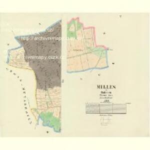
Milles - c4765-1-001 - Kaiserpflichtexemplar der Landkarten des stabilen Katasters
1 : 2880
Porostní mapa revíru Nový Dvůr
1 : 10000
Weschekun - c8938-1-001 - Kaiserpflichtexemplar der Landkarten des stabilen Katasters
1 : 2880
Weschekun - c8938-1-004 - Kaiserpflichtexemplar der Landkarten des stabilen Katasters
1 : 2880
Weschekun - c8938-1-002 - Kaiserpflichtexemplar der Landkarten des stabilen Katasters
1 : 2880
Weschekun - c8938-1-003 - Kaiserpflichtexemplar der Landkarten des stabilen Katasters
1 : 2880
Lusen - c4335-1-003 - Kaiserpflichtexemplar der Landkarten des stabilen Katasters
1 : 2880
Lusen - c4335-1-001 - Kaiserpflichtexemplar der Landkarten des stabilen Katasters
1 : 2880
Lusen - c4335-1-002 - Kaiserpflichtexemplar der Landkarten des stabilen Katasters
1 : 2880
Ujest - c8212-1-001 - Kaiserpflichtexemplar der Landkarten des stabilen Katasters
1 : 2880
Ujest - c8212-1-003 - Kaiserpflichtexemplar der Landkarten des stabilen Katasters
1 : 2880
Ujest - c8212-1-002 - Kaiserpflichtexemplar der Landkarten des stabilen Katasters
1 : 2880
Katastrální mapa obce Lužná WC-XIV-21 cf
1 : 2880
Katastrální mapa obce Lužná WC-XIV-21 bg
1 : 2880
Přehledová mapa velkostatku Tachov
1 : 17280
Innichen - c4615-1-001 - Kaiserpflichtexemplar der Landkarten des stabilen Katasters
1 : 2880
Innichen - c4615-1-002 - Kaiserpflichtexemplar der Landkarten des stabilen Katasters
1 : 2880
Innichen - c4615-1-003 - Kaiserpflichtexemplar der Landkarten des stabilen Katasters
1 : 2880
Gr.Meyerhöfen - c8422-1-001 - Kaiserpflichtexemplar der Landkarten des stabilen Katasters
1 : 2880
Gr.Meyerhöfen - c8422-1-002 - Kaiserpflichtexemplar der Landkarten des stabilen Katasters
1 : 2880
Gr.Meyerhöfen - c8422-1-003 - Kaiserpflichtexemplar der Landkarten des stabilen Katasters
1 : 2880
Katastrální mapa obce Lužná WC-XIV-21 bf
1 : 2880
III. vojenské mapování 4149/2
1 : 25000
Gradkartenblatt
1 : 25000 Přimda-oblast (Česko) Bulla, Eduard
[Kartenblatt]
1 : 25000 Bor (Tachov, Česko : oblast) Reichsamt für Landesaufnahme

Uibersichtskarte der Herrschaft Tachau
Tachov-oblast (Česko) Waraus, E. André Verlag des böhm. Forstvereins