Maps of Útěchovice

Milotitz - c4679-1-001 - Kaiserpflichtexemplar der Landkarten des stabilen Katasters
1 : 2880
Milotitz - c4679-1-002 - Kaiserpflichtexemplar der Landkarten des stabilen Katasters
1 : 2880
Gr.Autiechowitz - c8281-1-002 - Kaiserpflichtexemplar der Landkarten des stabilen Katasters
1 : 2880
Gr.Autiechowitz - c8281-1-004 - Kaiserpflichtexemplar der Landkarten des stabilen Katasters
1 : 2880
Gr.Autiechowitz - c8281-1-003 - Kaiserpflichtexemplar der Landkarten des stabilen Katasters
1 : 2880
Gr.Autiechowitz - c8281-1-001 - Kaiserpflichtexemplar der Landkarten des stabilen Katasters
1 : 2880
Maschowitz - c4526-1-002 - Kaiserpflichtexemplar der Landkarten des stabilen Katasters
1 : 2880
Maschowitz - c4526-1-001 - Kaiserpflichtexemplar der Landkarten des stabilen Katasters
1 : 2880
Batzowitz - c0054-1-003 - Kaiserpflichtexemplar der Landkarten des stabilen Katasters
1 : 2880
Batzowitz - c0054-1-002 - Kaiserpflichtexemplar der Landkarten des stabilen Katasters
1 : 2880
Batzowitz - c0054-1-001 - Kaiserpflichtexemplar der Landkarten des stabilen Katasters
1 : 2880
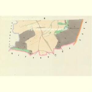
Bitietitz - c0245-1-001 - Kaiserpflichtexemplar der Landkarten des stabilen Katasters
1 : 2880
Bitietitz - c0245-1-002 - Kaiserpflichtexemplar der Landkarten des stabilen Katasters
1 : 2880

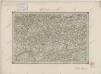
Gradkartenblatt
1 : 25000 Pelhřimov-oblast (Česko) Bulla, Eduard
[Gradkartenblatt]
1 : 25000 Pelhřimov-oblast (Česko) Vojenský zeměpisný ústav
Pelhřimov - Humpolec

Podrobné mapy zemí Koruny české v měřítku 1:75.000 a mapy vzdáleností všech míst při silnici ležících
1 : 75000 Mladá Vožice (Česko : oblast) Bělohlav, Josef F. Topič
III. vojenské mapování 4254
1 : 75000
Pelhřimov
1 : 75000 Pelhřimov-oblast (Česko) Vojenský zeměpisný ústav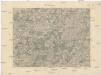
Pelhřimov
1 : 75000 Pelhřimov (Česko : oblast) Vojenský zeměpisný ústav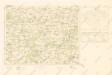
Mapy plánování ČSR

Soubor přehledných map pro plánování a statistiku: 4254 – Pelhřimov

Kamenitz a/d. Linde
1 : 75000 Kamenice nad Lipou (Česko : oblast) Fenzl K. u. k. militär-geographisches Institut
Kamenitz a/d. Linde
1 : 75000 Kamenice nad Lipou (Česko : oblast) Fenzl K. u. k. Militärgeographisches Institut
Kamenitz a/d. Linde
1 : 75000 Kamenice nad Lipou (Česko : oblast) K. u. k. Militärgeographisches Institut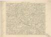
Podrobná místopisná mapa Království Českého

Podrobná mapa Království českého
1 : 100000 Humpolec (Pelhřimov, Česko : oblast) Srp, Jan Jaroslav Bursík
Podrobná místopisná mapa Království Českého