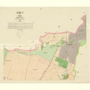
Maps of Libuň

Libun - c4060-1-002 - Kaiserpflichtexemplar der Landkarten des stabilen Katasters
1 : 2880
Libun - c4060-1-003 - Kaiserpflichtexemplar der Landkarten des stabilen Katasters
1 : 2880
Libun - c4060-1-001 - Kaiserpflichtexemplar der Landkarten des stabilen Katasters
1 : 2880
Libunetz - c4059-1-002 - Kaiserpflichtexemplar der Landkarten des stabilen Katasters
1 : 2880
Libunetz - c4059-1-001 - Kaiserpflichtexemplar der Landkarten des stabilen Katasters
1 : 2880
Knischnitz (Knižnice) - c3206-1-003 - Kaiserpflichtexemplar der Landkarten des stabilen Katasters
1 : 2880
Knischnitz (Knižnice) - c3206-1-002 - Kaiserpflichtexemplar der Landkarten des stabilen Katasters
1 : 2880
Knischnitz (Knižnice) - c3206-1-001 - Kaiserpflichtexemplar der Landkarten des stabilen Katasters
1 : 2880
Knischnitz (Knižnice) - c3206-1-004 - Kaiserpflichtexemplar der Landkarten des stabilen Katasters
1 : 2880
Hollenitz (Holenice) - c1957-1-003 - Kaiserpflichtexemplar der Landkarten des stabilen Katasters
1 : 2880
Hollenitz (Holenice) - c1957-1-001 - Kaiserpflichtexemplar der Landkarten des stabilen Katasters
1 : 2880
Hollenitz (Holenice) - c1957-1-002 - Kaiserpflichtexemplar der Landkarten des stabilen Katasters
1 : 2880
Mapa lesů revíru Mladějov
1 : 2880
Augezd - c8232-1-003 - Kaiserpflichtexemplar der Landkarten des stabilen Katasters
1 : 2880
Augezd - c8232-1-004 - Kaiserpflichtexemplar der Landkarten des stabilen Katasters
1 : 2880
Augezd - c8232-1-001 - Kaiserpflichtexemplar der Landkarten des stabilen Katasters
1 : 2880
Augezd - c8232-1-002 - Kaiserpflichtexemplar der Landkarten des stabilen Katasters
1 : 2880
Augezd - c8232-1-005 - Kaiserpflichtexemplar der Landkarten des stabilen Katasters
1 : 2880
Břeska - c0587-1-001 - Kaiserpflichtexemplar der Landkarten des stabilen Katasters
1 : 2880
Břeska - c0587-1-003 - Kaiserpflichtexemplar der Landkarten des stabilen Katasters
1 : 2880
Břeska - c0587-1-002 - Kaiserpflichtexemplar der Landkarten des stabilen Katasters
1 : 2880
Ginolitz - c2919-1-002 - Kaiserpflichtexemplar der Landkarten des stabilen Katasters
1 : 2880
Ginolitz - c2919-1-001 - Kaiserpflichtexemplar der Landkarten des stabilen Katasters
1 : 2880

Mapa okresu Lomnického na Jičínsku
1 : 25000 Lomnice nad Popelkou-oblast (Česko) Fučík, Josef Jan nákladem národopisného odboru
Karte der Denkmale der im Treffen bei Jičín am 29-ten Juni 1866 Gefallenen

Přehledná mapa velkostatku Jičíněves - Kopidlno
1 : 23040
Podrobné mapy zemí Koruny české v měřítku 1:75.000 a mapa vzdáleností všech míst při silnici ležících - Turnov - Sobotka - Jičín - Paka. Průvodce statisticko-historický po všech místech na těchto mapách uvedených a rejstřík věcný názvů hor, potoků, řek, rybníků atd. Sešit 15. List 79,
1 : 75000
Politický a školní okres Semilský
1 : 100000 Semily (Česko : okres : 1960-) Fučík, Josef Jan Jos.J. Fučík