Maps of Radenín

Laschan - c3829-1-002 - Kaiserpflichtexemplar der Landkarten des stabilen Katasters
1 : 2880
Laschan - c3829-1-001 - Kaiserpflichtexemplar der Landkarten des stabilen Katasters
1 : 2880
Laschan - c3829-1-003 - Kaiserpflichtexemplar der Landkarten des stabilen Katasters
1 : 2880
Kozmitz - c3462-1-005 - Kaiserpflichtexemplar der Landkarten des stabilen Katasters
1 : 2880
Kozmitz - c3462-1-001 - Kaiserpflichtexemplar der Landkarten des stabilen Katasters
1 : 2880
Kozmitz - c3462-1-003 - Kaiserpflichtexemplar der Landkarten des stabilen Katasters
1 : 2880
Kozmitz - c3462-1-004 - Kaiserpflichtexemplar der Landkarten des stabilen Katasters
1 : 2880
Kozmitz - c3462-1-002 - Kaiserpflichtexemplar der Landkarten des stabilen Katasters
1 : 2880
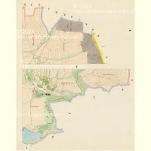
Poržin - c6036-1-005 - Kaiserpflichtexemplar der Landkarten des stabilen Katasters
1 : 2880
Poržin - c6036-1-003 - Kaiserpflichtexemplar der Landkarten des stabilen Katasters
1 : 2880
Poržin - c6036-1-004 - Kaiserpflichtexemplar der Landkarten des stabilen Katasters
1 : 2880
Poržin - c6036-1-001 - Kaiserpflichtexemplar der Landkarten des stabilen Katasters
1 : 2880
Poržin - c6036-1-002 - Kaiserpflichtexemplar der Landkarten des stabilen Katasters
1 : 2880
Kladrub - c3115-1-001 - Kaiserpflichtexemplar der Landkarten des stabilen Katasters
1 : 2880
Kladrub - c3115-1-002 - Kaiserpflichtexemplar der Landkarten des stabilen Katasters
1 : 2880
Zahostitz - c9065-1-001 - Kaiserpflichtexemplar der Landkarten des stabilen Katasters
1 : 2880
Zahostitz - c9065-1-002 - Kaiserpflichtexemplar der Landkarten des stabilen Katasters
1 : 2880
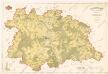
[Gradkartenblatt]
1 : 25000 Pacov-oblast (Pelhřimov, Česko)

Polohopisná mapa silnic, cest a obecního majetku Táborského
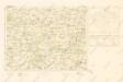
Mapy plánování ČSR

Soubor přehledných map pro plánování a statistiku: 4254 – Pelhřimov

Kamenitz a/d. Linde
1 : 75000 Kamenice nad Lipou (Česko : oblast) Fenzl K. u. k. militär-geographisches Institut
Kamenitz a/d. Linde
1 : 75000 Kamenice nad Lipou (Česko : oblast) Fenzl K. u. k. Militärgeographisches Institut
Kamenitz a/d. Linde
1 : 75000 Kamenice nad Lipou (Česko : oblast) K. u. k. Militärgeographisches Institut
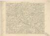
Tabor
1 : 75000 Bechyně (Česko : oblast) Deppisch K. u. k. militär-geographisches Institut
Tabor
1 : 75000 Bechyně (Česko : oblast) Deppisch K. u. k. Militärgeographisches Institut
Tabor
1 : 75000 Tábor (Česko : oblast) K. u. k. Militärgeographisches Institut